
Portal:Geography
The Geography Portal

Geography (from Ancient Greek γεωγραφία geōgraphía; combining gê 'Earth' and gráphō 'write') is the study of the lands, features, inhabitants, and phenomena of Earth. Geography is an all-encompassing discipline that seeks an understanding of Earth and its human and natural complexities—not merely where objects are, but also how they have changed and come to be. While geography is specific to Earth, many concepts can be applied more broadly to other celestial bodies in the field of planetary science. Geography has been called "a bridge between natural science and social science disciplines."
Origins of many of the concepts in geography can be traced to Greek Eratosthenes of Cyrene, who may have coined the term "geographia" (c. 276 BC – c. 195/194 BC). The first recorded use of the word γεωγραφία was as the title of a book by Greek scholar Claudius Ptolemy (100 – 170 AD). This work created the so called "Ptolemaic tradition" of geography, which included "Ptolemaic cartographic theory." However, the concepts of geography (such as cartography) date back to the earliest attempts to understand the world spatially, with the earliest example of an attempted world map dating to the 9th century BCE in ancient Babylon. The history of geography as a discipline spans cultures and millennia, being independently developed by multiple groups, and cross-pollinated by trade between these groups. The core concepts of geography consistent between all approaches are a focus on space, place, time, and scale.
Today, geography is an extremely broad discipline with multiple approaches and modalities. There have been multiple attempts to organize the discipline, including the four traditions of geography, and into branches. Techniques employed can generally be broken down into quantitative and qualitative approaches, with many studies taking mixed-methods approaches. Common techniques include cartography, remote sensing, interviews, and surveying. (Full article...)
 Featured article -
-


SNAE expedition ship Scotia, in the ice at Laurie Island, South Orkneys, 1903–1904
The Scottish National Antarctic Expedition (SNAE), 1902–1904, was organised and led by William Speirs Bruce, a natural scientist and former medical student from the University of Edinburgh. Although overshadowed in terms of prestige by Robert Falcon Scott's concurrent Discovery Expedition, the SNAE completed a full programme of exploration and scientific work. Its achievements included the establishment of a staffed meteorological station, the first in Antarctic territory, and the discovery of new land to the east of the Weddell Sea. Its large collection of biological and geological specimens, together with those from Bruce's earlier travels, led to the establishment of the Scottish Oceanographical Laboratory in 1906.
Bruce had spent most of the 1890s engaged on expeditions to the Antarctic and Arctic regions, and by 1899 was Britain's most experienced polar scientist. In March of that year, he applied to join the Discovery Expedition; however, his proposal to extend that expedition's field of work into the Weddell Sea quadrant, using a second ship, was dismissed as "mischievous rivalry" by Royal Geographical Society (RGS) president Sir Clements Markham. Bruce reacted by obtaining independent finance; his venture was supported and promoted by the Royal Scottish Geographical Society. (Full article...) -

Bath (RP: /bɑːθ/; local pronunciation: [ba(ː)θ]) is a city in the ceremonial county of Somerset, England, known for and named after its Roman-built baths. At the 2021 Census, the population was 94,092. Bath is in the valley of the River Avon, 97 miles (156 km) west of London and 11 miles (18 km) southeast of Bristol. The city became a UNESCO World Heritage Site in 1987, and was later added to the transnational World Heritage Site known as the "Great Spa Towns of Europe" in 2021. Bath is also the largest city and settlement in Somerset.
The city became a spa with the Latin name Aquae Sulis ("the waters of Sulis") c. 60 AD when the Romans built baths and a temple in the valley of the River Avon, although hot springs were known even before then. Bath Abbey was founded in the 7th century and became a religious centre; the building was rebuilt in the 12th and 16th centuries. In the 17th century, claims were made for the curative properties of water from the springs, and Bath became popular as a spa town in the Georgian era. Georgian architecture, crafted from Bath stone, includes the Royal Crescent, Circus, Pump Room, and the Assembly Rooms, where Beau Nash presided over the city's social life from 1705 until his death in 1761. (Full article...) -

Ireland is an island in Northern Europe in the north Atlantic Ocean. The island, of up to around 480 km north-south, and 275 km east-west, lies near the western edge of the European continental shelf, part of the Eurasian Plate. Its main geographical features include low central plains surrounded by coastal mountains. The highest peak is Carrauntoohil (Irish: Corrán Tuathail), which is 1,039 metres (3,409 ft) above sea level. The western coastline is rugged, with many islands, peninsulas, headlands and bays, while the southern and northern coasts feature a smaller number of substantial sea inlets, such as Lough Foyle and Cork Harbour; no part of the land is more than around 110 km from the sea. It was administratively divided into 32 counties, gathered in 4 provinces, though current arrangements, especially in Northern Ireland, differ from this model. The island is almost bisected by the River Shannon, which at 360.5 km (224 mi) with a 102.1 km (63 mi) estuary is the longest river in Ireland and flows south from County Cavan in the province of Ulster to form the boundary between Connacht and Leinster, and later Munster, and meet the Atlantic just south and west of Limerick. There are a number of sizeable lakes along Ireland's rivers, of which Lough Neagh is the largest.
Politically, the island consists of the Republic of Ireland, with jurisdiction over about five-sixths of the island, and Northern Ireland, a constituent part of the United Kingdom, with jurisdiction over the remaining sixth. Located west of the island of Great Britain, Ireland lies at approximately . It has a total area of 84,421 km2 (32,595 sq mi) and is separated from Great Britain by the Irish Sea, bounded to the north and south respectively by the North Channel and St George's Channel, and from mainland Europe by the Celtic Sea. Ireland forms the second largest landmass in the North-West European Archipelago, together with nearby islands including Great Britain and the Isle of Man, known in the United Kingdom as the British Isles. (Full article...) -
Covent Garden is a district in London, on the eastern fringes of the West End, between St Martin's Lane and Drury Lane. It is associated with the former fruit-and-vegetable market in the central square, now a popular shopping and tourist site, and with the Royal Opera House, itself known as "Covent Garden". The district is divided by the main thoroughfare of Long Acre, north of which is given over to independent shops centred on Neal's Yard and Seven Dials, while the south contains the central square with its street performers and most of the historical buildings, theatres and entertainment facilities, including the London Transport Museum and the Theatre Royal, Drury Lane.
The area was fields until briefly settled in the 7th century when it became the heart of the Anglo-Saxon trading town of Lundenwic, then abandoned at the end of the 9th century after which it returned to fields. By 1200 part of it had been walled off by the Abbot of Westminster Abbey for use as arable land and orchards, later referred to as "the garden of the Abbey and Convent", and later "the Convent Garden". Following the Dissolution of the Monasteries it was granted in 1552 by the young King Edward VI to John Russell, 1st Earl of Bedford (c.1485–1555), the trusted adviser to his father King Henry VIII. The 4th Earl commissioned Inigo Jones to build some fine houses to attract wealthy tenants. Jones designed the Italianate arcaded square along with the church of St Paul's. The design of the square was new to London and had a significant influence on modern town planning, acting as the prototype for new estates as London grew. (Full article...) -
The War of the Fifth Coalition was a European conflict in 1809 that was part of the Napoleonic Wars and the Coalition Wars. The main conflict took place in Central Europe between the Austrian Empire of Francis I and Napoleon's French Empire. The French were supported by their client states—the Kingdom of Italy, the Confederation of the Rhine and the Duchy of Warsaw. Austria was supported by the Fifth Coalition which included the United Kingdom, Portugal, Spain, and the Kingdoms of Sardinia and Sicily, although the latter two took no part in the fighting. By the start of 1809 much of the French army was committed to the Peninsular War against Britain, Spain and Portugal. After France withdrew 108,000 soldiers from Germany, Austria attacked France to seek the recovery of territories lost in the 1803–1806 War of the Third Coalition. The Austrians hoped Prussia would support them, having recently been defeated by France, but Prussia chose to remain neutral.
On 10 April 1809, Austrian forces under Archduke Charles crossed the border of Bavaria, a French client state. The French response, under Louis-Alexandre Berthier, was disorganised but order was imposed with the arrival of Napoleon on 17 April. Napoleon led an advance to Landshut, hoping to cut off the Austrian line of retreat and sweep into their rear. Charles crossed the Danube at Regensburg, which allowed him to retreat eastwards, although he failed to reach the Austrian capital, Vienna, before the French. A French assault across the Danube was repulsed on 21–22 May at the Battle of Aspern-Essling but a repeat attack was successful in July. Napoleon won a major victory at the 5–6 July Battle of Wagram, which forced the Austrians to sign the Armistice of Znaim on 12 July. Austrian invasions of the Duchy of Warsaw and Saxony (where they fought alongside the Black Brunswickers) were repulsed and they were driven out of their territories in Italy. British forces landed in Walcheren, in the French client state of Holland, but were unable to seize their objective of capturing Antwerp and were later withdrawn. (Full article...) -
Omayra Sánchez Garzón (August 28, 1972 – November 16, 1985) was a Colombian girl trapped and killed by a landslide when she was 13 years old.
The landslide was caused by the 1985 eruption of the volcano Nevado del Ruiz in Armero, Tolima. Volcanic debris mixed with ice to form massive lahars (volcanically induced mudflows, landslides, and debris flows), which rushed into the river valleys below the mountain, killing about 25,000 people and destroying Armero and 13 other villages. (Full article...) -
Grand Teton National Park is an American national park in northwestern Wyoming. At approximately 310,000 acres (1,300 km2), the park includes the major peaks of the 40-mile-long (64 km) Teton Range as well as most of the northern sections of the valley known as Jackson Hole. Grand Teton National Park is only 10 miles (16 km) south of Yellowstone National Park, to which it is connected by the National Park Service–managed John D. Rockefeller Jr. Memorial Parkway. Along with surrounding national forests, these three protected areas constitute the almost 18-million-acre (73,000-square-kilometer) Greater Yellowstone Ecosystem, one of the world's largest intact mid-latitude temperate ecosystems.
The human history of the Grand Teton region dates back at least 11,000 years when the first nomadic hunter-gatherer Paleo-Indians began migrating into the region during warmer months to pursue food and supplies. In the early 19th century, the first explorers encountered the eastern Shoshone natives. Between 1810 and 1840, the region attracted fur trading companies that vied for control of the lucrative beaver pelt trade. U.S. government expeditions to the region commenced in the mid-19th century as an offshoot of exploration in Yellowstone, with the first permanent white settlers in Jackson Hole arriving in the 1880s. (Full article...) -
Trafford is a metropolitan borough of Greater Manchester, England, with an estimated population of 235,546 in 2021. It covers 106 square kilometres (41 sq mi) and includes the area of Old Trafford and the towns of Altrincham, Stretford, Urmston, Partington and Sale. The borough was formed in 1974 as a merger of six former districts and part of a seventh. The River Mersey flows through the borough, separating North Trafford from South Trafford, and the historic counties of Lancashire and Cheshire. Trafford is the seventh-most populous district in Greater Manchester.
There is evidence of Neolithic, Bronze Age, and Roman activity in the area, two castles – one of them a Scheduled Ancient Monument – and over 200 listed buildings. In the late 19th century, the population rapidly expanded with the arrival of the railway. Trafford is the home of Manchester United F.C. and Lancashire County Cricket Club, as well as Altrincham F.C. and Trafford F.C.. The Imperial War Museum North, opened in 2002, is located in the borough. (Full article...) -
Fridtjof Wedel-Jarlsberg Nansen (Norwegian: [ˈfrɪ̂tːjɔf ˈnɑ̀nsn̩]; 10 October 1861 – 13 May 1930) was a Norwegian polymath and Nobel Peace Prize laureate. He gained prominence at various points in his life as an explorer, scientist, diplomat, humanitarian and co-founded the Fatherland League.
He led the team that made the first crossing of the Greenland interior in 1888, traversing the island on cross-country skis. He won international fame after reaching a record northern latitude of 86°14′ during his Fram expedition of 1893–1896. Although he retired from exploration after his return to Norway, his techniques of polar travel and his innovations in equipment and clothing influenced a generation of subsequent Arctic and Antarctic expeditions. He was elected an International Member of the American Philosophical Society in 1897. (Full article...) -
The Volcano, also known as Lava Fork volcano, is a small cinder cone in the Boundary Ranges of the Coast Mountains in northwestern British Columbia, Canada. It is located approximately 60 km (40 mi) northwest of the small community of Stewart near the head of Lava Fork. With a summit elevation of 1,656 m (5,433 ft) and a topographic prominence of 311 m (1,020 ft), it rises above the surrounding rugged landscape on a remote mountain ridge that represents the northern flank of a glaciated U-shaped valley.
Lava Fork volcano is associated with a small group of volcanoes called the Iskut volcanic field. This forms part of the much larger Northern Cordilleran Volcanic Province, which extends from the Alaska–Yukon border to near the port city of Prince Rupert, British Columbia. Eruptive activity at The Volcano is relatively young compared to most other volcanoes in the Northern Cordilleran Volcanic Province. Geologic studies have shown that The Volcano and its eruptive products were emplaced in the last 400 years; this is well after the last glacial period, which ended about 10,000 years ago. (Full article...) -
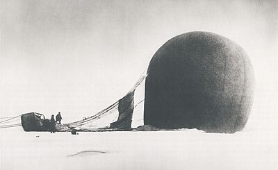
S. A. Andrée and Knut Frænkel with the balloon on the pack ice, photographed by the third expedition member, Nils Strindberg. The exposed film for this photograph and others from the failed 1897 expedition was recovered in 1930.
Andrée's Arctic balloon expedition of 1897 was a failed Swedish effort to reach the North Pole, resulting in the deaths of all three expedition members, S. A. Andrée, Knut Frænkel, and Nils Strindberg. Andrée, the first Swedish balloonist, proposed a voyage by hydrogen balloon from Svalbard to either Russia or Canada, which was to pass, with luck, straight over the North Pole on the way. The scheme was received with patriotic enthusiasm in Sweden, a northern nation that had fallen behind in the race for the North Pole.
Andrée ignored many early signs of the dangers associated with his balloon plan. Being able to steer the balloon to some extent was essential for a safe journey, but there was much evidence that the drag-rope steering technique he had invented was ineffective. Worse, the polar balloon Örnen (Eagle) was delivered directly to Svalbard from its manufacturer in Paris without being tested. When measurements showed it to be leaking more than expected, Andrée failed to acknowledge the risk. (Full article...) -
Keswick (/ˈkɛzɪk/ KEZ-ik) is a market town and civil parish in the Cumberland unitary authority area of Cumbria, England. Historically, until 1974, it was part of the county of Cumberland. It lies within the Lake District National Park, Keswick is just north of Derwentwater and is four miles (six kilometres) from Bassenthwaite Lake. The parish had a population of 5,243 at the 2011 census.
There is evidence of prehistoric occupation of the area, but the first recorded mention of the town dates from the 13th century, when Edward I of England granted a charter for Keswick's market, which has maintained a continuous 700-year existence. The town was an important mining area, and from the 18th century has been known as a holiday centre; tourism has been its principal industry for more than 150 years. Its features include the Moot Hall; a modern theatre, the Theatre by the Lake; one of Britain's oldest surviving cinemas, the Alhambra; and the Keswick Museum and Art Gallery in the town's largest open space, Fitz Park. Among the town's annual events is the Keswick Convention, an Evangelical gathering attracting visitors from many countries. (Full article...) -

Bulgaria, officially the Republic of Bulgaria, is a country in Southeast Europe. Located west of the Black Sea and south of the Danube river, Bulgaria is bordered by Greece and Turkey to the south, Serbia and North Macedonia to the west, and Romania to the north. It covers a territory of 110,994 square kilometres (42,855 sq mi) and is the 16th largest country in Europe. Sofia is the nation's capital and largest city; other major cities include Burgas, Plovdiv, and Varna.
One of the earliest societies in the lands of modern-day Bulgaria was the Neolithic Karanovo culture, which dates back to 6,500 BC. In the 6th to 3rd century BC, the region was a battleground for ancient Thracians, Persians, Celts and Macedonians; stability came when the Roman Empire conquered the region in AD 45. After the Roman state splintered, tribal invasions in the region resumed. Around the 6th century, these territories were settled by the early Slavs. The Bulgars, led by Asparuh, attacked from the lands of Old Great Bulgaria and permanently invaded the Balkans in the late 7th century. They established the First Bulgarian Empire, victoriously recognised by treaty in 681 AD by the Byzantine Empire. It dominated most of the Balkans and significantly influenced Slavic cultures by developing the Cyrillic script. The First Bulgarian Empire lasted until the early 11th century, when Byzantine emperor Basil II conquered and dismantled it. A successful Bulgarian revolt in 1185 established a Second Bulgarian Empire, which reached its apex under Ivan Asen II (1218–1241). After numerous exhausting wars and feudal strife, the empire disintegrated and in 1396 fell under Ottoman rule for nearly five centuries. (Full article...) -
William Speirs Bruce FRSE (1 August 1867 – 28 October 1921) was a British naturalist, polar scientist and oceanographer who organised and led the Scottish National Antarctic Expedition (SNAE, 1902–04) to the South Orkney Islands and the Weddell Sea. Among other achievements, the expedition established the first permanent weather station in Antarctica. Bruce later founded the Scottish Oceanographical Laboratory in Edinburgh, but his plans for a transcontinental Antarctic march via the South Pole were abandoned because of lack of public and financial support.
In 1892 Bruce gave up his medical studies at the University of Edinburgh and joined the Dundee Whaling Expedition to Antarctica as a scientific assistant. This was followed by Arctic voyages to Novaya Zemlya, Spitsbergen and Franz Josef Land. In 1899 Bruce, by then Britain's most experienced polar scientist, applied for a post on Robert Falcon Scott's Discovery Expedition, but delays over this appointment and clashes with Royal Geographical Society (RGS) president Sir Clements Markham led him instead to organise his own expedition, and earned him the permanent enmity of the geographical establishment in London. Although Bruce received various awards for his polar work, including an honorary doctorate from the University of Aberdeen, neither he nor any of his SNAE colleagues were recommended by the RGS for the prestigious Polar Medal. (Full article...) -
General Gregor MacGregor (24 December 1786 – 4 December 1845) was a Scottish soldier, adventurer, and confidence trickster who attempted from 1821 to 1837 to draw British and French investors and settlers to "Poyais", a fictional Central American territory that he claimed to rule as "Cazique". Hundreds invested their savings in supposed Poyaisian government bonds and land certificates, while about 250 emigrated to MacGregor's invented country in 1822–23 to find only an untouched jungle; more than half of them died. Seen as a contributory factor to the "Panic of 1825", MacGregor's Poyais scheme has been called one of the most brazen confidence tricks in history.
From the Clan Gregor, MacGregor was an officer in the British Army from 1803 to 1810; he served in the Peninsular War. He joined the republican side in the Venezuelan War of Independence in 1812, quickly became a general and, over the next four years, operated against the Spanish on behalf of both Venezuela and its neighbour New Granada. His successes included a difficult month-long fighting retreat through northern Venezuela in 1816. He captured Amelia Island in 1817 under a mandate from revolutionary agents to conquer Florida from the Spanish, and there proclaimed a short-lived "Republic of the Floridas". He then oversaw two calamitous operations in New Granada during 1819 that each ended with his abandoning British volunteer troops under his command. (Full article...)


.jpg)
.jpg)


 Vital article
.svg)
Related portals
Get involved
 |
Here are some tasks awaiting attention:
|
Selected pictures
-
 Map credit: Central Intelligence AgencyThe Robinson projection is a projection of a world map showing the entire Earth at once. It was specifically created in an attempt to find a good compromise to the problem of showing the whole globe as a single flat image. The projection was devised by Arthur H. Robinson in 1963; distortion is severe close to the poles, but quickly declines to moderate levels as latitudes decrease. This Robinson-projection map, with standard parallels of 38°N and 38°S, was produced by the United States Central Intelligence Agency and shows the world as of February 2016.
 -
 Photo credit: NASAAntarctica, the continent surrounding the Earth's South Pole, is the coldest place on earth and is almost entirely covered by ice. Antarctica was discovered in late January 1820. Too cold and dry to support virtually any vascular plants, Antartica's flora presently consists of around 250 lichens, 100 mosses, 25-30 liverworts, and around 700 terrestrial and aquatic algal species.
 -
 Earth at nightPhoto credit: NASA and NOAAEarth at night.
The northernmost settlement on Earth is Alert, Ellesmere Island, Canada. The southernmost is the Amundsen–Scott South Pole Station, in Antarctica. -
 Map: Strebe, using GeocartThe Gall–Peters projection, named after James Gall and Arno Peters, is a specialization of a configurable equal-area map projection known as the cylindrical equal-area projection. It achieved considerable notoriety in the late 20th century as the centerpiece of a controversy surrounding the political implications of map design; Peters promoted it as a more faithful representation than the Mercator projection, which inflates the sizes of regions farther from the equator and thus makes the (mostly technologically underdeveloped) equatorial countries appear smaller and therefore, according to Peters, less significant.
 -
 Illustration credit: Joaquim Alves Gaspar, after Jorge de AguiarA compass rose, sometimes called a windrose or rose of the winds, is a figure on a compass, map, nautical chart, or monument used to display the orientation of the cardinal directions (north, east, south, and west) and their intermediate points. It is also the term for the graduated markings found on the traditional magnetic compass. Today, a form of compass rose is found on, or featured in, almost all navigation systems, including nautical charts, non-directional beacons, VHF omnidirectional range systems, GPS, and similar equipment.
This picture is an illustration of a compass rose, copied from a 1492 portolan chart by Portuguese navigator and cartographer Jorge de Aguiar, now in the Beinecke Rare Book & Manuscript Library. -
 Map: Strebe, using GeocartThe Eckert II projection is an equal-area pseudocylindrical map projection presented by Max Eckert-Greifendorff in 1906. In the equatorial aspect (where the equator is shown as the horizontal axis) the network of longitude and latitude lines consists solely of straight lines, and the outer boundary has the distinctive shape of an elongated hexagon.
 -
 Map: Strebe, using GeocartThe sinusoidal projection is a pseudocylindrical equal-area map projection. Used as early as the 16th century, this projection shows distances accurately along the central meridian and the equator; areas furthest from these lines are the most distorted.
 -
 A detailed eighteenth-century map of Scandinavia by J. B. Homann, depicting Denmark, Norway, Sweden, Finland and the Baltic states of Livonia, Latvia and Curlandia. The map notes fortified cities, villages, roads, bridges, forests, castles and topography. The elaborate title cartouche in the upper left quadrant features angels supporting a title curtain and a medallion supporting an alternative title in French, "Les Trois Covronnes du Nord".
Born in 1664, Homann became an engraver and cartographer in the late 17th century, and opened his own publishing house in 1702. In 1715 Emperor Charles VI appointed him Imperial Geographer of the Holy Roman Empire. Homann held the position until his death in 1724. -
 Map: Strebe, using GeocartThe Chamberlin trimetric projection is a map projection where three points are fixed on the globe and the points on the sphere are mapped onto a plane by triangulation. It was developed in 1946 by Wellman Chamberlin for the National Geographic Society. It is neither conformal nor equal-area, but rather attempts to minimize distortion of distances everywhere with the side-effect of balancing between areal equivalence and conformality.
 -
 Map: Johannes Vingboons; Restoration: Lise BroerA c. 1650 map showing the Island of California, a long-held European misconception, dating from the 16th century, that California was not part of mainland North America but rather a large island separated from the continent by a strait now known instead as the Gulf of California. The belief persisted until the expeditions of Juan Bautista de Anza in 1774–76.
 -
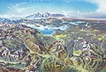 Map credit: Heinrich C. BerannYellowstone National Park is an American national park located mostly in Wyoming and extending into Montana and Idaho. It was established by the U.S. Congress and signed into law by President Ulysses S. Grant on March 1, 1872. Yellowstone was the first national park in the U.S. and is also widely held to be the first national park in the world. The park is known for its wildlife and its many geothermal features, especially the Old Faithful geyser, one of its most popular landmarks. It has many types of ecosystems, but the subalpine forest is the most abundant. The park is part of the South Central Rockies forests ecoregion. In 1978, Yellowstone was named a World Heritage Site by UNESCO.
This picture is a stylized panoramic map of Yellowstone National Park as viewed from the northeast, created in 1991 by Austrian painter and cartographer Heinrich C. Berann for the National Park Service. Yellowstone Lake and the Grand Canyon of the Yellowstone are in the center, while Old Faithful is visible on the right, next to a brown building representing the Old Faithful Inn. Jackson Lake and the peaks of the Teton Range are depicted in the background. -
 Map credit: Heinrich C. BerannNorth Cascades National Park is an American national park in the state of Washington. At more than 500,000 acres (200,000 ha), North Cascades National Park is the largest of the three National Park Service units that comprise the North Cascades National Park Complex. North Cascades National Park consists of a northern and southern section, bisected by the Skagit River that flows through Ross Lake National Recreation Area. Lake Chelan National Recreation Area lies on the southern border of the south unit of the park. In addition to the two national recreation areas, other protected lands including several national forests and wilderness areas, as well as Canadian provincial parks in British Columbia, nearly surround the park. North Cascades National Park features the rugged mountain peaks of the North Cascades Range, the most expansive glacial system in the contiguous United States, the headwaters of numerous waterways, and vast forests with the highest degree of flora biodiversity of any American national park.
This picture is a panoramic map of North Cascades National Park, as viewed from the east, created in 1987 by Austrian painter and cartographer Heinrich C. Berann for the National Park Service. -
 A satellite image of the Sahara, the world's largest hot desert and second largest desert after Antarctica at over 9,000,000 km² (3,500,000 mi²), almost as large as the United States. The Sahara is located in Northern Africa and is 2.5 million years old.
 -
 Map: Strebe, using the Geocart map projection softwareA two-point equidistant projection of Eurasia. All distances of other points from the two points marked in red (45°N 40°E and 30°N 110°E) are correct. This map is a derivative of NASA's Blue Marble summer month composite, with oceans lightened to enhance legibility and contrast.
 -
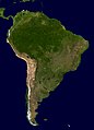 A composite relief satellite image of South America, the fourth-largest continent. South America occupies the southern portion of the landmass in the Western Hemisphere. The continent is generally delimited on the northwest by the Darién watershed along the Colombia–Panama border. Almost all of mainland South America sits on the South American Plate, as do nearby outlying islands.


.jpg)


Featured biography

Edward Wright (baptised 8 October 1561; died November 1615) was an English mathematician and cartographer noted for his book Certaine Errors in Navigation (1599; 2nd ed., 1610), which for the first time explained the mathematical basis of the Mercator projection by building on the works of Pedro Nunes, and set out a reference table giving the linear scale multiplication factor as a function of latitude, calculated for each minute of arc up to a latitude of 75°. This was in fact a table of values of the integral of the secant function, and was the essential step needed to make practical both the making and the navigational use of Mercator charts.
Wright was born at Garveston in Norfolk and educated at Gonville and Caius College, Cambridge, where he became a fellow from 1587 to 1596. In 1589 the college granted him leave after Elizabeth I requested that he carry out navigational studies with a raiding expedition organised by the Earl of Cumberland to the Azores to capture Spanish galleons. The expedition's route was the subject of the first map to be prepared according to Wright's projection, which was published in Certaine Errors in 1599. The same year, Wright created and published the first world map produced in England and the first to use the Mercator projection since Gerardus Mercator's original 1569 map. (Full article...)Did you know
- ... that glaciation in Wisconsin 17 thousand years ago helped create its unique geography?
- ... that Johann Reinhold Forster's 1778 book Observations Made During a Voyage Round the World has been described as "the beginning of modern geography"?
Places around you
Top 10 WikiProject Geography Popular articles of the month
-

A map of the United States showing its 50 states, federal district and five inhabited territories. Alaska, Hawaii, and the territories are shown at different scales, and the Aleutian Islands and the uninhabited northwestern Hawaiian Islands are omitted from this map.
The United States of America is a federal republic consisting of 50 states, a federal district (Washington, D.C., the capital city of the United States), five major territories, and various minor islands. Both the states and the United States as a whole are each sovereign jurisdictions. The Tenth Amendment to the United States Constitution allows states to exercise all powers of government not delegated to the federal government. Each state has its own constitution and government, and all states and their residents are represented in the federal Congress, a bicameral legislature consisting of the Senate and the House of Representatives. Each state is represented by two senators, while representatives are distributed among the states in proportion to the most recent constitutionally mandated decennial census. Additionally, each state is entitled to select a number of electors to vote in the Electoral College, the body that elects the president of the United States, equal to the total of representatives and senators in Congress from that state. The federal district does not have representatives in the Senate, but has a non-voting delegate in the House, and it is also entitled to electors in the Electoral College. Congress can admit more states, but it cannot create a new state from territory of an existing state or merge two or more states into one without the consent of all states involved, and each new state is admitted on an equal footing with the existing states. (Full article...) -
Generation Z (often shortened to Gen Z), colloquially known as Zoomers, is the demographic cohort succeeding Millennials and preceding Generation Alpha. Researchers and popular media use the mid-to-late 1990s as starting birth years and the early 2010s as ending birth years. Most members of Generation Z are the children of Generation X or older Millennials. (Full article...)
-
Earth is the third planet from the Sun and the only astronomical object known to harbor life. This is enabled by Earth being a water world, the only one in the Solar System sustaining liquid surface water. Almost all of Earth's water is contained in its global ocean, covering 70.8% of Earth's crust. The remaining 29.2% of Earth's crust is land, most of which is located in the form of continental landmasses within Earth's land hemisphere. Most of Earth's land is somewhat humid and covered by vegetation, while large sheets of ice at Earth's polar deserts retain more water than Earth's groundwater, lakes, rivers and atmospheric water combined. Earth's crust consists of slowly moving tectonic plates, which interact to produce mountain ranges, volcanoes, and earthquakes. Earth has a liquid outer core that generates a magnetosphere capable of deflecting most of the destructive solar winds and cosmic radiation. (Full article...) -

Google Maps is a web mapping platform and consumer application offered by Google. It offers satellite imagery, aerial photography, street maps, 360° interactive panoramic views of streets (Street View), real-time traffic conditions, and route planning for traveling by foot, car, bike, air (in beta) and public transportation. , Google Maps was being used by over one billion people every month around the world. (Full article...) -
Millennials, also known as Generation Y (often shortened to Gen Y), are the demographic cohort following Generation X and preceding Generation Z. Researchers and popular media use the early 1980s as starting birth years and the mid-1990s to early 2000s as ending birth years, with the generation typically being defined as people born from 1981 to 1996. Most Millennials are the children of Baby Boomers and older Generation X. In turn Millennials are often the parents of Generation Alpha. (Full article...)
-

Hong Kong is a special administrative region of the People's Republic of China. With 7.4 million residents of various nationalities in a 1,104-square-kilometre (426 sq mi) territory, Hong Kong is one of the most densely populated territories in the world. (Full article...) -
Generation X (often shortened to Gen X) is the demographic cohort following the Baby Boomers and preceding Millennials. Researchers and popular media often use the mid-1960s as its starting birth years and the late 1970s as its ending birth years, with the generation being generally defined as people born from 1965 to 1980. By this definition and U.S. Census data, there are 65.2 million Gen Xers in the United States as of 2019. Most of Generation X are the children of the Silent Generation and early Baby Boomers; Xers are also often the parents of Millennials and Generation Z. (Full article...)
-
London is the capital and largest city of both England and the United Kingdom, with a population of around 8.8 million, and its metropolitan area is the largest in Western Europe, with a population of 14.8 million. It stands on the River Thames in south-east England at the head of a 50-mile (80 km) estuary down to the North Sea and has been a major settlement for nearly two millennia. The City of London, its ancient core and financial centre, was founded by the Romans as Londinium and retains its medieval boundaries. The City of Westminster, to the west of the City of London, has for centuries hosted the national government and parliament. In the 19th century, London grew rapidly, becoming the world's largest city at the time, as it expanded and absorbed the neighbouring county of Middlesex, and parts of Surrey and Kent. In 1965 it was combined with parts of Essex and Hertfordshire to create the administrative area of Greater London, which is governed by 33 local authorities and the Greater London Authority. (Full article...) -

England is a country that is part of the United Kingdom. The country is located on the island of Great Britain, of which it covers roughly 62%, and over 100 smaller adjacent islands. It has land borders with Scotland to the north and Wales to the west, and is otherwise surrounded by the North Sea to the east, the English Channel to the south, the Celtic Sea to the south-west, and the Irish sea to the west. Continental Europe lies to the south-east, and Ireland to the west. The population was 56,490,048 at the 2021 census. London is both the largest city and the capital. (Full article...) -
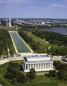
Washington, D.C., formally the District of Columbia and commonly called Washington or D.C., is the capital city and federal district of the United States. The city is on the Potomac River, across from Virginia, and shares land borders with Maryland to its north and east. Washington, D.C., was named for George Washington, a Founding Father and the first president of the United States. The district is named for Columbia, the female personification of the nation. (Full article...)

.jpg)

.jpeg)


Featured pictures


Main articles
 Categories
Associated Wikimedia
The following Wikimedia Foundation sister projects provide more on this subject:
-
 Commons
Free media repository -
 Wikibooks
Free textbooks and manuals -
 Wikidata
Free knowledge base -
 Wikinews
Free-content news -
 Wikiquote
Collection of quotations -
 Wikisource
Free-content library -
 Wikiversity
Free learning tools -
 Wikivoyage
Free travel guide -
 Wiktionary
Dictionary and thesaurus


