
Venhuizen
Venhuizen | |
|---|---|
Village | |
 | |
 Flag  Coat of arms | |
 Venhuizen Location in the Netherlands  Venhuizen Location in the province of North Holland in the Netherlands | |
| Coordinates: 52°39′47″N 5°12′39″E / 52.66306°N 5.21083°E | |
| Country | Netherlands |
| Province | North Holland |
| Municipality | Drechterland |
| Area | |
| • Total | 8.50 km2 (3.28 sq mi) |
| Elevation | −1.0 m (−3.3 ft) |
| Population (2021)[1] | |
| • Total | 4,310 |
| • Density | 510/km2 (1,300/sq mi) |
| Time zone | UTC+1 (CET) |
| • Summer (DST) | UTC+2 (CEST) |
| Postal code | 1606[1] |
| Dialing code | 0228 |
Venhuizen (Dutch: [vɛnˈɦœyzə(n)] ⓘ; West Frisian: Fenhúze) is a town in the north-western Netherlands, in the province of North Holland and the region of West-Frisia, in the municipality of Drechterland. Venhuizen was a separate municipality until 1 January 2006, when it was merged with the existing municipality of Drechterland. It was decided to call the new municipality Drechterland.
On a map of the Hollands Noorderkwartier from 1288 is Venhuizen mentioned as Veenhusen. The name could be referring to houses at or in the fen. The Dutch Reformed church dates from the 15th century. The other large church is the Roman Catholic St. Lucaskerk (St. Lucas church), built in 1956. It's also locally called the tough (robust) church (nl: stoere).
Culture[edit]
The village fest occurs every year with Pentecost and entails a fun fair, a horse race, a volleyball tournament and several festivals. Since 2017 there is also a yearly food festival in Venhuizen named Food Festival Venhuizen. It is the largest open air restaurant in West Frisia with more than 8,000 visitors. In 2020 it will be on 9 and 10 May on De Vliegende Faam in the center of the village.
Notable people[edit]
- Hendrik Offerhaus (born 20 May 1875), rower
- Rob Compas (born 10 November 1966), road bicycle racer
- Rick Hooijboer (born 3 August 1974), football player
- Mathieu Boots (born 23 June 1976), soccer player
- Peter Koning (born 3 December 1990), racing cyclist
Gallery[edit]
-
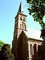 Dutch Reformed Church in Venhuizen
 -
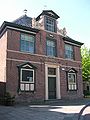 The former town hall from 1662.
 -
 St. Lucaskerk.
 -
 Restaurant next to the former town hall from 1662
 -
 One of the typical houses at Venhuizen
 -
 The Teun Sluis-iceskating rink at Venhuizen


References[edit]
- ^ a b c "Kerncijfers wijken en buurten 2021". Central Bureau of Statistics. Retrieved 29 April 2022.
includes Drieban
- ^ "Postcodetool for 1606AA". Actueel Hoogtebestand Nederland (in Dutch). Het Waterschapshuis. Retrieved 29 April 2022.
| International | |
|---|---|
| National | |
This North Holland location article is a stub. You can help Wikipedia by expanding it. |