Elliot Lake Municipal Airport
Elliot Lake Municipal Airport | |||||||||||
|---|---|---|---|---|---|---|---|---|---|---|---|
 | |||||||||||
| Summary | |||||||||||
| Airport type | Public | ||||||||||
| Owner/Operator | City of Elliot Lake | ||||||||||
| Location | Elliot Lake | ||||||||||
| Time zone | EST (UTC−05:00) | ||||||||||
| • Summer (DST) | EDT (UTC−04:00) | ||||||||||
| Elevation AMSL | 1,086 ft / 331 m | ||||||||||
| Coordinates | 46°21′06″N 082°33′40″W / 46.35167°N 82.56111°W | ||||||||||
| Map | |||||||||||
| Runways | |||||||||||
| |||||||||||
| Statistics (2010) | |||||||||||
| |||||||||||
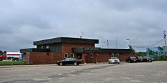
Elliot Lake Municipal Airport (IATA: YEL, ICAO: CYEL) is a registered aerodrome located 4 nautical miles (7.4 km; 4.6 mi) southeast of the city of Elliot Lake, Ontario, Canada.
Facilities[edit]

The airport consists of a small brick single storey terminal building. Other than a small waiting area there are no other services inside. Food is available for pilots only.[4][better source needed]
To the west of the terminal are storage sheds and hangars for general aviation aircraft.
Tenants[edit]
There are no schedule airlines operating to and from this airport, but facilities exists to handle them.[5]
Current tenants include:[5]
- Air Bravo – air ambulance operator based in Blind River, Ontario; flies to and from Elliot Lake[6]
- Mining company transport – two flights transport to Red Lake every two weeks
- Dynamex – logistics and freight services operator flies to and from Elliot Lake on contracts to clients in the area
- Private flight for an ear/nose/throat specialist who flies into Elliot Lake once a week
- Hope Air – provides free medical transport to those in need in the area[7]
The closest airports with scheduled passenger services are Sault Ste. Marie Airport and Greater Sudbury Airport.
Technical information[edit]
General[edit]
- Magnetic Variation: 9° west
The aerodrome is operated by the City of Elliot Lake and is registered by Transport Canada.
Runways[edit]
- Runway 12/30: 4,495 by 100 ft (1,370 by 30 m), paved, lighted, PAPI type 2 approach lighting at both ends
Communications[edit]
- Unicom/ATF: Elliot Lake Unicom/Traffic 123.0 MHz
- PAL: Toronto Centre 135.4 MHz
AWOS 122.175
[edit]
- NDB: Elliot Lake (YEL), 276 kHz, 2.7 nautical miles (5.0 km; 3.1 mi) 123° to airport. As of recently (2022) however, the NDB has been decommissioned.
References[edit]
- ^ Canada Flight Supplement. Effective 0901Z 16 July 2020 to 0901Z 10 September 2020.
- ^ Synoptic/Metstat Station Information Archived December 1, 2011, at the Wayback Machine
- ^ Total aircraft movements by class of operation
- ^ Elliot Lake Airport at COPA
- ^ a b Elliot Lake Airport - General Information
- ^ Air Bravo Corp - Air Ambulance
- ^ Hope Air
External links[edit]
- Airport website
- Past three hours METARs, SPECI and current TAFs for Elliot Lake Municipal Airport from Nav Canada as available.

