
Talk:List of Washington Metro stations
| This is the talk page for discussing improvements to the List of Washington Metro stations article. This is not a forum for general discussion of the article's subject. |
Article policies
|
| Find sources: Google (books · news · scholar · free images · WP refs) · FENS · JSTOR · TWL |
| List of Washington Metro stations is a former featured list. Please see the links under Article milestones below for its original nomination page and why it was removed. If it has improved again to featured list standard, you may renominate the article to become a featured list. | ||||||||||||||||
| ||||||||||||||||
| Current status: Former featured list | ||||||||||||||||
| This article is rated List-class on Wikipedia's content assessment scale. It is of interest to the following WikiProjects: | |||||||||||||||||||||||||||||||||||||||||||||
| |||||||||||||||||||||||||||||||||||||||||||||


Comments[edit]
Wow, that's gnarly. This page sits untouched for months, then two of us start wikifying the stations. Should we decide on some sort of uniform format, like what the Wikipedia:WikiProject_Station Stations tried to do, but has apparently lay idle?
Also, what about format for the station pages names? There is no present Wikiproject for station (naming). I took a cue from the tube stations (where one is Acton Town tube station), and named mine Foggy Bottom-GWU Washington Metro station. Now, "Metro Center" is pretty unique, but I just wanted input. I'm new here, but already hopelessly addicted, and scared to death that I'm doing things wrong. --Golbez 03:04, 22 Mar 2004 (UTC)
Just another thought - if we have to disambiguate station pages, then that creates some non-standard names.
For example, we would have: Foggy Bottom-GWU Tenleytown-AU Van Ness-UDC
But then we would require disambiguated names for ones like: Rockville Vienna Smithsonian Anacostia
So should we just go with one format? I'm gonna play around in the Wikiproject now.
Color boxes[edit]
The color boxes need to go. These are not accessible for blind users or users of text-based browsers or monochrome monitors. --NE2 06:56, 6 October 2007 (UTC)
- I hover over the boxes with my mouse, and I see text pop up, which indicates to me that they're sufficiently accessible. SchuminWeb (Talk) 13:19, 6 October 2007 (UTC)
- Not really... if you have a monochrome monitor, or you're colorblind, you'll have to hover over each one to see what it is. --NE2 14:23, 6 October 2007 (UTC)
Premature for Purple to be on here?[edit]
Does anyone else think it's still slightly premature to have Purple Line stations on here? SchuminWeb (Talk) 14:44, 26 July 2008 (UTC)
- I agree; it's not even 'planned', according to our article it's still in the proposal stage. --Golbez (talk) 17:31, 26 July 2008 (UTC)
- Sounds good to me. SchuminWeb (Talk) 03:45, 3 August 2008 (UTC)
New York Avenue[edit]
I called up the Office of the Red Line Manager at Metro and was told that NY Ave-Fl Ave-Gallaudet is B35. The person that I talked to will try to get the PR office or someone whose name is already public to email me something.Naraht (talk) 13:56, 16 October 2008 (UTC)
Images on right margin[edit]
I recently added a row of images along the right margin, in line with current FL station lists like List of Bay Area Rapid Transit stations. It was reverted with the concern that the images may cause crowding with the table for users with smaller screens. Since I've been working on tweaking the list for an FL nom, I'd like to add the images back in, but wanted to seek input from other editors of the page. To whit:
- Should the images be added back in?
- Is there a way to prevent the issue ShuminWeb was concerned about that cause the reversion, while still having the images to meet FLC precedent?
- Geraldk (talk) 12:30, 22 May 2009 (UTC)
Improvements and updates needed[edit]
Working on a rail system station list of my own, I've been looking at this list as a reference due to its FL status. But I can't help and feel there are a few improvements that can be made here since it was promoted to the status back in 2009.
- Station codes – I don't really feel as if these are necessary because they are only used internally by WMATA. The original citation of the user-created track map is an unreliable source. I searched forever to find a document on WMATA's site with the codes listed and only came across one. Seeing as it was so hard to find on the site, I doubt its very important or relevant. I still haven't been able to find a reliable source for the Silver Line codes.
- "Top stations by ridership" section – This section seems redundant since the ridership is already listed in the main section, and any viewer can easily sort the table to see which stations have the highest ridership. Although, the figures are different between the two tables. The main table lists Union Station as having a daily ridership of 34,465, while the other table lists 32,935. The dates for the information are also pretty old, as old as May 2006 and only as recent as 2009. I also tagged the list with {{update}}.
This would probably get demoted in a featured list review candidate, which I'd like to avoid, so hopefully we can update this and decide whether to keep additional content. –Dream out loud (talk) 02:13, 4 February 2011 (UTC)
- I don't see how they hurt, and they are helpful is articulating the sequence of stations along each line. Internal documents can be reliable sources, and printed materials are reliable sources even if they are not posted on the WMATA website. 66.173.140.100 (talk) 21:59, 9 February 2011 (UTC)
- I don't think it hurts either but just because something "doesn't hurt" doesn't mean it should be kept. Plus the opening date column takes care of the opening sequence of the stations along the lines. I personally don't think its too important because I don't think the codes are widely used or notable to be included in the article (unlike Amtrak station codes). As far as sources go, the one for the current stations is fine, but I can't find any type of source for the Silver Line stations. Finding the codes for the other station was hard enough. After only seeing one document on the whole website that contains the codes, I questioned myself as to whether they are that important. This is definitely something that requires a consensus to be made. –Dream out loud (talk) 00:39, 10 February 2011 (UTC)
- I don't see how they hurt, and they are helpful is articulating the sequence of stations along each line. Internal documents can be reliable sources, and printed materials are reliable sources even if they are not posted on the WMATA website. 66.173.140.100 (talk) 21:59, 9 February 2011 (UTC)
- Actually, sorting the stations by ridership doesn't work properly. The sort is essentially "alphabetic" rather than numerical, resulting in this:
- McPherson Square 17,370
- Rosslyn 18,122
- Capitol Heights 2,221
- Eisenhower Avenue 2,496
- You see the problem. Can this be fixed? Currently there is no way to see which stations have the highest (or lowest) ridership without sifting through the entire table. I'd fix it if I knew how, but I don't. --Tkynerd (talk) 18:20, 1 November 2011 (UTC)
- The ridership needs to be within {{nts}}, for instance
{{nts|9539}}. The software will add the spacing commas and will sort is properly. This needs to be done for all the stations. This is similar to how the opening dates use {{dts}}. Arsenikk (talk) 19:07, 1 November 2011 (UTC)- It's because 2 comes after 1, in computer-speak. There's a way to code it with leading zeroes. In other words, where Rosslyn has 18,122--five spaces--we have to put for Capitol Heights, 02,221. When coded right, the leading zeroes do not show in the article; the coding just instructs the system in how to order it. I accomplished this correction in some articles with countries listed by area and population, showing the same problem; I figured out how to do it by looking at pages where it came out right. Whenever I get a chance, I might try to undertake it here (it's tricky, finicky work; I briefly made a country disappear, by omitting a square bracket). 173.79.191.234 (talk) 13:03, 27 November 2011 (UTC)Stephen Kosciesza
- The ridership needs to be within {{nts}}, for instance
Time to get this back to a Featured List[edit]
I was disappointed to see that this was de-featured back in April. It's a good list, and the basic structure is still there. But, there's a lot to do, which I'm starting now:
- Remove the station codes; they're an internal designator only and they don't serve any conceivable purpose here.
- Update ridership data to 2010 data when it becomes possible
- Update stats in the lead section at least to 2009 data, and preferably to 2010
And some thoughts of my own:
- Improve coverage and explanation of the Silver Line
- Add more pictures to the right-hand side of the page
And future work:
- Update each year when ridership data is available
- Add new station colors in 2012 when the Yellow and Orange lines have alternate peak-hour routings
I'm starting on this work now; any help would be appreciated. Pi.1415926535 (talk) 15:38, 14 July 2011 (UTC)
- I have now removed the station codes, and updated all stats in the lead section to 2010 data save one 2009. I rewrote part of the into, and all of the Planned Stations section. Added projected opening dates to the future stations, and there's commented-out color boxes all ready to go for next year's service changes.
- I also put out feelers outside of Wikipedia for full 2010 data, so we'll see about that. Now to add some pictures and I'll be done for the night. Pi.1415926535 (talk) 04:27, 15 July 2011 (UTC)
November Updates[edit]
Hi. I used the Template:nts to fix the number sorting and I also put in the latest passenger boarding data from FY2011 from WMATA. Let me know if you have any questions. Best, epicAdam(talk) 20:11, 1 November 2011 (UTC)
- epicAdam, you've lived up to your username. That looks fantastic, and great catch with the Wolf Trap station that's completely vanished from consideration. With your addition of 2011 data, this is just about ready to go back to FLC to return to its former status as a featured list. Pi.1415926535 (talk) 00:01, 2 November 2011 (UTC)
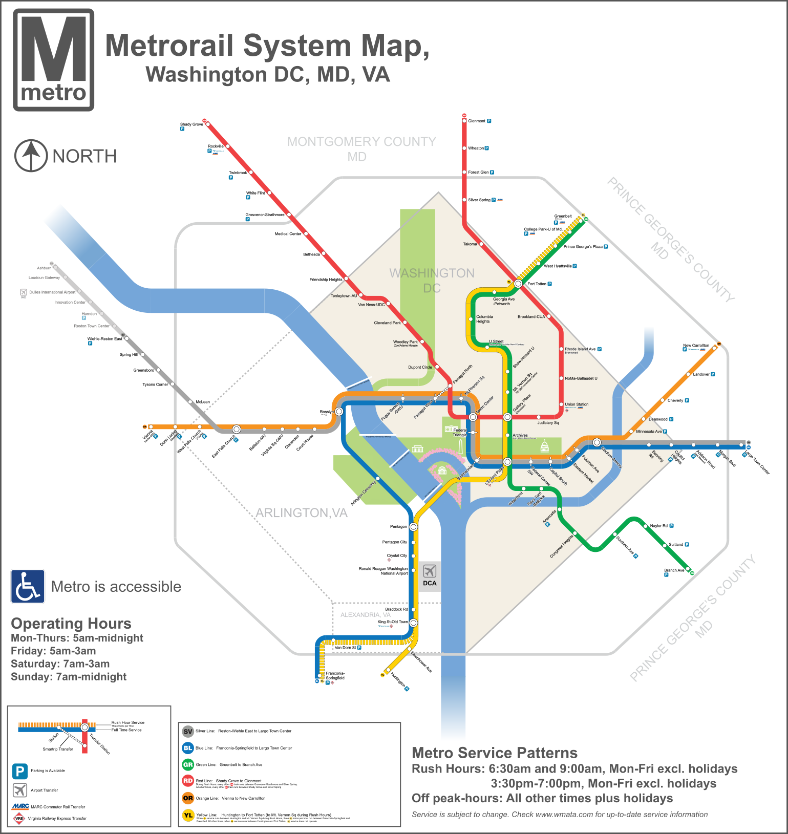
Lack of consistency on the Orange icon[edit]
In the map up top, the Orange Circle has "OR" in white, just as the one on the WMATA website does, however below, it is in black. I realize that putting it in white may cause problems with the white stripped circles indicating Rush hour. Should be make it consistent?Naraht (talk) 16:23, 5 April 2013 (UTC)
 Done I've updated the non-rush icon to white text as with the official map, though the rush icon will need to stay black for the time being. Unfortunately, for some reason the white version isn't displaying in the article yet. Pi.1415926535 (talk) 17:59, 5 April 2013 (UTC)
About the to-do list[edit]
In March of 2014, I had already taken care of one item on the to-d list for this article: I moved the lines from the first to the second column of the "Stations" table and the "Planned Stations" table. Also, should there be a "grade/layout" column indicating whether the Washington Metro's stations are elevated, at-grade or underground? Jim856796 (talk) 09:36, 6 July 2014 (UTC)
- Good work. I'd say specifying the construction type probably isn't worthwhile, but I'm open to thoughts. Pi.1415926535 (talk) 18:32, 4 August 2014 (UTC)
Station code refs[edit]
The following web pages at wmata.com include the station codes:
- http://api.wmata.com/StationPrediction.svc/GetPrediction/All?api_key=5qtaymv2kg65cw8bukqz7wph
- http://api.wmata.com/Rail.svc/Stations?api_key=8vezeb6xjcn3aw595y43wx75
- https://www.wmata.com/business/procurement_and_contracting/solicitations/uploads/WMATA_FQ11248_3_Amendment_12.pdf
Connections[edit]
Just a thought- would it be a good idea to show connections to other rail lines on this page? I feel like connections to VRE, MARC, and Amtrak would all make sense on this list, especially considering that they are important enough to go on the map. I believe the corresponding article for the Chicago rapid transit system (List of CTA stations) has commuter rail connections. Just something to consider. Rivkid007 (talk) 05:37, 16 October 2014 (UTC)
- Sure, go ahead. Ten commuter rail stations is probably enough to add a column. Pi.1415926535 (talk) 22:57, 16 October 2014 (UTC)
ref number reordering...[edit]
The references at the top of the main table include those that are [9][4]. I know there is a tool that will help with making all groups of ref numbers in Chronological order, but I don't remember what it is. :(Naraht (talk) 20:57, 26 August 2015 (UTC)
- That shows up as a task for the users that check with AutoWikiBrowser; it's all taken care of now. Pi.1415926535 (talk) 00:28, 28 August 2015 (UTC)
Washington Metro map[edit]
@Pi.1415926535: Just so you know the "2013" has many outdated station names but all texts in that SVG are illegibly small, hard-converted into path shapes and no raw text remains. That means it is not modification-friendly to Wikimedia's principles. As the one who reworked the map from scratch, I am not obliged to duplicate the style of the old map just for pleasing your taste. -- Sameboat - 同舟 (talk · contri.) 23:02, 27 November 2015 (UTC)
- While I respect the work you have put into your map, sweat of the brow is not reason enough to replace a superior map, regardless of that map's flaws (some of which are easily fixed by anyone who has a better vector editor than I). Your map has a number of objective flaws - some minor, others systemic - and others which are subjective yet I argue are hallmarks of a quality map. If you can fix these and make your map superior to what is currently available on Wikimedia, I will welcome it replacing the 2013 map.
- First, your map warps geography far more than necessary. The Silver Line runs west more than north, and indeed goes farther west than the Orange Line. The Blue Line runs southeast through Arlington Cemetery; because you do not show this, your map has a huge gap between L'Enfant and Pentagon. The Green Line runs substantially southeast to Branch Avenue and northeast to Greenbelt. The kinks in the Green Line in its southern third, the Red Line where it switches from Connecticut to Wisconsin, the Blue-Orange-Silver east of Eastern Market, and the hook of the Green and Yellow lines are all notable elements of the city's geography that residents use for wayfinding.
- Second, you have factual errors and omissions. The Orange Line no longer runs to Largo. You do not show Amtrak, nor differentiate between the commuter rail systems. Crystal City is considered a VRE transfer. Several of your station names have errors (University is not spelled out at NoMa, Dunn Loring has a subtitle) and WMATA considers the long part of many station names to be subtitles (which cleans up typography enormously). There's some bad kerning - Town, Van, War, Yard, and wherever Avenue appears among them. The color names aren't aligned in their bubbles.
- Third, the 2013 map is a visually pleasant map whereas yours could use some polishing. The Beltway, county lines, parks, and memorials are incredibly important for wayfinding. The rivers are barely visible in yours. The 2013 map has a clear and useful legend and shows accessibility, parking, and bridges. Its thicker, angular route lines render better at small scale (there are too many stations for either map to have its text render well at small scales). There is a reason it was based off the official map - Lance Wyman's map is a masterpiece of attractive and useful transit map design. Pi.1415926535 (talk) 03:38, 28 November 2015 (UTC)
- The error of Orange Line has already been fixed but I am not gonna add or change any thing to make it any closer to the official map (with consideration of copyright issue) which is not necessry in a topological diagram as opposed to geographical map. My map only requires a notepad to modify, but the old map requires advanced graphic software (Adobe Illystrator) and knowledge to change. Wiki is a place for collaboration, not making thing inaccessible for other contributors. -- Sameboat - 同舟 (talk · contri.) 04:13, 28 November 2015 (UTC)
- Regarding the kerning issue, this is how librsvg renderer on Wikimedia handles raw text. Like it or not, it is still a mile better than hard-converting raw text into path shapes because the raw text allows the vector image to be searchable by Google. -- Sameboat - 同舟 (talk · contri.) 04:32, 28 November 2015 (UTC)
- Editability is a smaller issue than you're making it out to be. This map will likely need no more than a handful of text modifications - a small number of station name changes, and opening of the Silver Line and perhaps Potomac Yard - before it become obsolete around 2020 when the Purple Line opens. (The Purple Line is going to so fundamentally alter both the geometry of the Metro system and its downtown-oriented focus that completely new maps will be needed.) I have relatively basic Inkscape skills and no current access to Illustrator, and I'm making some of the changes myself in Inkscape and notepad.
- There is no need to have text in a vector map searchable; the file description page with a proper description and proper categorization are what makes maps findable, and Google doesn't always search inside SVGs anyway. Best practice for maps is to have the text layer converted to zero-width (to make future changes easier) and also convert it to path for proper rendering.
- While the Wyman map is clearly the inspiration, this map has enough differences that that inspiration would be considered de minimis and there is not a question of copyright.
- Your more recent changes have improved your map somewhat, and I understand that it is very good from a code point of view. However, the style of the 2013-designed map is better for use both for actual wayfinding and for illustrating an encyclopedia article. Why not spend some time improving that map - perhaps create an newer version with larger editable text and proper station names? Pi.1415926535 (talk) 22:13, 2 December 2015 (UTC)
- The station labels in the 2013 version is still so small even in 1539px wide resolution. Subtitle and legend explanatory text is not legible at all. From the point of usability of a rail diagram, this is an instant fail. To respond to your argument, Google does consistently (purposefully) treat and give proper web search result of raw SVG file like an HTML page as along as it contains true text instead of text converted into path shapes. Raw text allows straightforward search by keyword when the raw SVG file is opened directly in the browser (Ctrl+F and type the correct station name. Voila!) Having hidden text behind the text-shape is just too fiddly for future modification. (Face it, you didn't do it in your latest revision for the corrected labels like Ashburn). I admit that SVG text rendering is inconsistent between applications/SVG rendering engines, but I prefer substance over style (and try hard to make sure my diagrams look properly in most circumstances), not to mention the style you embrace so dearly is broken in the first place. -- Sameboat - 同舟 (talk · contri.) 01:52, 3 December 2015 (UTC)

- I have originally reserved space for the Purple Line but it was not drawn because (if I understand correctly) construction hasn't started yet. The afterthought inclusion of DC boundary somehow complicates the alignment in my map. Potomac Yard honestly adds little challenge. -- Sameboat - 同舟 (talk · contri.) 09:07, 3 December 2015 (UTC)
I have a few thoughts on this. I agree that the station text is preferable in Sameboat's version--it's readable in the default view, whereas you have to zoom in to see it on the 2013 version. I have mixed feelings about using generic icons to indicate connections with Amtrak/MARC/VRE. On US maps more than most it really does matter, because of all the weird jurisdictional boundaries. On the other hand, the system-specific icons are hard to see on the 2013 version. My main issue, as I think is Pi.1415926535's, is that the new map really does distort the geography of DC. The Central to DC's image is the diamond orientation of the district itself, which the map reflects (even the DC metro cars are angular). The wide circular turns really don't fit with that aesthetic (they're also inconsistent, which is a problem in itself). Mackensen (talk) 22:43, 3 December 2015 (UTC)
- The official and WM 2013 maps distort geography as well so the DC diamond can be positioned almost at the diagram center. Even one ignores Silver Line phase 2, the diamond is more to the east of the dimension of the whole system[1]. My point is, complaining my map geographically inaccurate is so unfair when geography is meant to be distorted in topological diagram for maximum legibility. It's just the matter of how much time the crowd takes to get used from one diagram to the other when modification is inevitable. -- Sameboat - 同舟 (talk · contri.) 05:37, 4 December 2015 (UTC)
External links modified[edit]
Hello fellow Wikipedians,
I have just modified 2 external links on List of Washington Metro stations. Please take a moment to review my edit. If you have any questions, or need the bot to ignore the links, or the page altogether, please visit this simple FaQ for additional information. I made the following changes:
- Added archive https://web.archive.org/web/20160222003449/http://www.wmata.com/about_metro/docs/Metro%20Facts%202014.pdf to http://www.wmata.com/about_metro/docs/Metro%20Facts%202014.pdf
- Added archive https://web.archive.org/web/20151107151007/http://www.wmata.com/pdfs/planning/2015_historical_rail_ridership.pdf to https://www.wmata.com/pdfs/planning/2015_historical_rail_ridership.pdf
When you have finished reviewing my changes, you may follow the instructions on the template below to fix any issues with the URLs.
This message was posted before February 2018. After February 2018, "External links modified" talk page sections are no longer generated or monitored by InternetArchiveBot. No special action is required regarding these talk page notices, other than regular verification using the archive tool instructions below. Editors have permission to delete these "External links modified" talk page sections if they want to de-clutter talk pages, but see the RfC before doing mass systematic removals. This message is updated dynamically through the template {{source check}} (last update: 18 January 2022).
- If you have discovered URLs which were erroneously considered dead by the bot, you can report them with this tool.
- If you found an error with any archives or the URLs themselves, you can fix them with this tool.
Cheers.—InternetArchiveBot (Report bug) 09:21, 12 May 2017 (UTC)
External links modified[edit]
Hello fellow Wikipedians,
I have just modified 3 external links on List of Washington Metro stations. Please take a moment to review my edit. If you have any questions, or need the bot to ignore the links, or the page altogether, please visit this simple FaQ for additional information. I made the following changes:
- Added archive https://www.webcitation.org/6HNIh4uSL?url=http://www.wmata.com/about_metro/docs/history.pdf to http://www.wmata.com/about_metro/docs/history.pdf
- Added archive https://web.archive.org/web/20140731154519/http://www.wmata.com/rail/stations.cfm to http://www.wmata.com/rail/stations.cfm
- Added archive https://www.webcitation.org/69VXkrujF?url=http://www.wmata.com/about_metro/docs/2010_Media_Guide.pdf to http://www.wmata.com/about_metro/docs/2010_Media_Guide.pdf
When you have finished reviewing my changes, you may follow the instructions on the template below to fix any issues with the URLs.
![]() An editor has reviewed this edit and fixed any errors that were found.
An editor has reviewed this edit and fixed any errors that were found.
- If you have discovered URLs which were erroneously considered dead by the bot, you can report them with this tool.
- If you found an error with any archives or the URLs themselves, you can fix them with this tool.
Cheers.—InternetArchiveBot (Report bug) 03:48, 28 December 2017 (UTC)
"Transfer station" between Metrorail lines, or anything?[edit]
There's a bit of back-and-forth starting, over designating Union Station as an official transfer station or not. The only way we would call Union Station a transfer station is by noting that one can transfer to other modes of transport--Amtrak, MARC, etc. I do notice that there are a couple of other stations designated transfer stations, that on transfer to other modesl But in that case, we'd have to include Silver Spring and Rockville; you can transfer to Amtrak and MARC at both of those. Uporządnicki (talk) 17:08, 29 December 2022 (UTC)
- Given that the official map does not designate Union Station and other stations with connections to mainline rail as transfer stations, I don't see why we would call them transfer stations. The column for "other rail connections" serves that purpose. Pi.1415926535 (talk) 22:01, 29 December 2022 (UTC)
- The fact that it has railroad transfers is *irrelevant*. Silver Spring and Rockville would be the same as Union Station if that were the reason. The map in the trains uses a double circle for Transfer Stations. These not only include stations like Metro Center and Gallery Place, it also includes Rosslyn, Pentagon and Union Station. These are all "divergent" stations where two lines going in the same direction go to *different* places.Naraht (talk) 23:36, 29 December 2022 (UTC)
- @Naraht: Please look at the current system map that I linked in my previous comment. Union Station is not a diverging point and is not marked as a transfer station. Pi.1415926535 (talk) 23:57, 29 December 2022 (UTC)
- Pi.1415926535,AzseicsoK I apologize, I was wrong. I got Union Station and Stadium armory mixed up in my head.~ :( :(Naraht (talk)
- @Naraht: Please look at the current system map that I linked in my previous comment. Union Station is not a diverging point and is not marked as a transfer station. Pi.1415926535 (talk) 23:57, 29 December 2022 (UTC)
- The fact that it has railroad transfers is *irrelevant*. Silver Spring and Rockville would be the same as Union Station if that were the reason. The map in the trains uses a double circle for Transfer Stations. These not only include stations like Metro Center and Gallery Place, it also includes Rosslyn, Pentagon and Union Station. These are all "divergent" stations where two lines going in the same direction go to *different* places.Naraht (talk) 23:36, 29 December 2022 (UTC)
- Wikipedia former featured lists
- List-Class United States articles
- High-importance United States articles
- List-Class United States articles of High-importance
- List-Class District of Columbia articles
- High-importance District of Columbia articles
- WikiProject District of Columbia articles
- List-Class Washington Metro articles
- Low-importance Washington Metro articles
- WikiProject Washington Metro articles
- WikiProject United States articles
- List-Class rail transport articles
- High-importance rail transport articles
- List-Class Stations articles
- WikiProject Stations articles
- List-Class Rapid transit articles
- Unknown-importance Rapid transit articles
- WikiProject Rapid transit articles
- Unknown-importance Washington Metro articles
- All WikiProject Trains pages
- Wikipedia pages with to-do lists