
Banneville-sur-Ajon
Banneville-sur-Ajon | |
|---|---|
Part of Malherbe-sur-Ajon | |
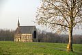
 The Chapel of Saint Clair | |
Location of Banneville-sur-Ajon  | |
 Banneville-sur-Ajon  Banneville-sur-Ajon | |
| Coordinates: 49°03′49″N 0°34′07″W / 49.0636°N 0.5686°W | |
| Country | France |
| Region | Normandy |
| Department | Calvados |
| Arrondissement | Vire |
| Canton | Les Monts d'Aunay |
| Commune | Malherbe-sur-Ajon |
| Area 1 | 5.63 km2 (2.17 sq mi) |
| Population (2019)[1] | 438 |
| • Density | 78/km2 (200/sq mi) |
| Time zone | UTC+01:00 (CET) |
| • Summer (DST) | UTC+02:00 (CEST) |
| Postal code | 14260 |
| Elevation | 84–184 m (276–604 ft) (avg. 141 m or 463 ft) |
| 1 French Land Register data, which excludes lakes, ponds, glaciers > 1 km2 (0.386 sq mi or 247 acres) and river estuaries. | |
Banneville-sur-Ajon is a former commune in the Calvados department in the Normandy region of north-western France. On 1 January 2016, it was merged into the new commune of Malherbe-sur-Ajon.[2]
Geography[edit]
Banneville-sur-Ajon is located some 20 km south-west of Caen and 7 km south-east of Villers-Bocage. Access to the commune is by the D121A from Saint-Agnan-le-Malherbe in the south which passes through the centre of the commune and the village and continues north to join the D8. The D171 from Landes-sur-Ajon to Préaux-Bocage passes through the north-east of the commune. Apart from the village there are the hamlets of La Fêterie in the south and Gournay in the north. The commune is almost all farmland.[3]
The Ajon river flows through the commune from south-east to north-west continuing to join the Odon south-west of Le Locheur. The Orgeuil river rises in the south of the commune and flows north-east through the length of the commune to join the Ajon. The Ruisseau de la Rette flows from the south to join the Orgeuil.[3]
Neighbouring communes and villages[3] | |
|---|---|
Toponymy[edit]
Banneville-sur-Ajon was Barneville sur Ajon in 1371.[4] René Lepelley attributed the origin of the name to the Germanic anthroponym Benno[5] with the Old French suffix -ville meaning "rural domain".
Administration[edit]
| From | To | Name |
|---|---|---|
| 1995 | 2001 | Jacques Vahe |
| 2001 | 2014 | Annick Viel-Schneider |
| 2014 | 2016 | Marcel Pétré |
Demography[edit]
The inhabitants of the commune are known as Bannevillais or Bannevillaises in French.[7]
|
| |||||||||||||||||||||||||||||||||||||||||||||||||||||||||||||||||||||||||||||||||||||||||||||||||||||||||||||||
| Source: EHESS[8] and INSEE[9] | ||||||||||||||||||||||||||||||||||||||||||||||||||||||||||||||||||||||||||||||||||||||||||||||||||||||||||||||||
Sites and monuments[edit]

- The Chapel of Saint-Clair (13th century)
 is registered as an historical monument.[10] The church is built on a simple rectangular plan. On the tympanum of the south portal there is a figure in bas-relief of Saint Samson on his throne, and inside is a statue of Saint Clair.
 - The Church of Saint-Melaine is in neo-Gothic style from the late 19th century.
- A replica of the grotto of Lourdes was built at a place called Le Village at the end of the Second World War.
Chapel Picture Gallery[edit]
-
 The Chapel of Saint Clair
 -
 A Detail in the Chapel
 -
 The Chapel
 -
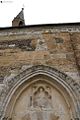 Detail on the Chapel
 -
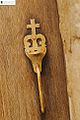 The door handle of the Chapel


See also[edit]
References[edit]
- ^ Téléchargement du fichier d'ensemble des populations légales en 2019, INSEE
- ^ Arrêté préfectoral 9 December 2015 (in French)
- ^ a b c Google Maps
- ^ Albert Dauzat and Charles Rostaing, Etymological Dictionary of place names in France, Larousse, Paris, 1963 (in French)
- ^ René Lepelley, Etymological Dictionary of names of communes in Normandy, Éditions Charles Corlet, Condé-sur-Noireau, 1996, BnF 36174448w, p. 58 (in French)
- ^ List of Mayors of France (in French)
- ^ Le nom des habitants du 14 - Calvados, habitants.fr
- ^ Des villages de Cassini aux communes d'aujourd'hui: Commune data sheet Banneville-sur-Ajon, EHESS (in French).
- ^ Populations légales 2012, INSEE
- ^ Ministry of Culture, Mérimée PA00111031 Chapel of Saint-Clair (in French)
External links[edit]
| Authority control databases: National |
|---|