
Grímsvötn
| Grímsvötn | |
|---|---|
 Grímsvötn and the Vatnajökull glacier, Iceland, July 1972 | |
| Highest point | |
| Elevation | 1,725 m (5,659 ft)[1] |
| Listing | List of volcanoes in Iceland |
| Coordinates | 64°25′12″N 17°19′48″W / 64.42000°N 17.33000°W |
| Geography | |
 Grímsvötn Austur-Skaftafellssýsla / Vestur-Skaftafellssýsla, Iceland | |
| Geology | |
| Mountain type | Volcanic caldera |
| Last eruption | May 2011 |
 Geological features near the Grímsvötn central volcano and its fissure swarm (red outlines). The fissure swarm's recent surface lava flows are shaded violet (darker if more recent). Shading also shows: calderas, other central volcanoes, fissure swarms, subglacial terrain above 1,100 m (3,600 ft), and seismically active areas. Clicking on the image enables full window and mouse-over with more detail. | |
Grímsvötn (Icelandic pronunciation: [ˈkrimsˌvœhtn̥] ⓘ;[2] vötn = "waters", singular: vatn) is an active volcano with a (partially subglacial) fissure system located in Vatnajökull National Park, Iceland. The volcano itself is completely subglacial and located under the northwestern side of the Vatnajökull ice cap. The subglacial caldera is at 64°25′N 17°20′W / 64.417°N 17.333°W, at an elevation of 1,725 m (5,659 ft). Beneath the caldera is the magma chamber of the Grímsvötn volcano.
Grímsvötn is a basaltic volcano which has the highest eruption frequency of all the volcanoes in Iceland and has a southwest-northeast-trending fissure system. The massive climate-impacting Laki fissure eruption of 1783–1784 was a part of the same Grímsvötn-Laki volcanic system.[3] Grímsvötn was erupting at the same time as Laki during 1783, but continued to erupt until 1785. Because most of the volcanic system lies underneath Vatnajökull, most of its eruptions have been subglacial and the interaction of magma and meltwater from the ice causes phreatomagmatic explosive activity.[4] Within the Grímsvötn-Laki volcanic system is a second central volcano called Thordarhyrna (Þórðarhyrna).[5]
Jökulhlaup[edit]
Eruptions in the caldera regularly cause glacial outbursts known as jökulhlaup.[6] Eruptions or geothermal activity, melt enough ice to fill the Grímsvötn caldera with water, and the pressure may be enough to suddenly lift the ice cap, allowing huge quantities of water to escape rapidly. Earthquakes and seismic tremor may occur.[7] Jökulhlaup can occur independent of eruptions or be followed by eruptions.[7] Jökulhlaup independent of eruptions occurred in November, December 2021 and October 2022.[7] Jökulhlaup which were followed by eruptions occurred in 1922, 1934 and 2004.[7] Consequently, the Grímsvötn caldera is monitored very carefully.
When a large eruption occurred in 1996, geologists knew well in advance that a glacial burst was imminent. It did not occur until several weeks after the eruption finished, but monitoring[8] ensured that the Icelandic ring road (Hringvegur) was closed when the burst occurred. A section of road across the Skeiðará sandur was washed away in the ensuing flood, but no one was hurt.
Eruption history between 1990 and today[edit]
Gjálp 1996[edit]
(See also the main article: 1996 eruption of Gjálp
The Gjálp fissure vent eruption in 1996 revealed that an interaction may exist between Bárðarbunga and Grímsvötn. A strong earthquake in Bárðarbunga, about magnitude 5 , is believed to have started the eruption in Gjálp. On the other hand, because of the magma erupted showed strong connections to the Grímsvötn Volcanic System acc. to petrology studies, the 1996 as well as a former eruption there in the 1930s are thought to have taken place within Grímsvötn Volcanic system.[9][10]
1998 and 2004 eruptions[edit]

A week-long eruption occurred at Grímsvötn starting on 28 December 1998, but no glacial burst occurred. In November 2004, a week-long eruption occurred. Volcanic ash from the eruption fell as far away as mainland Europe and caused short-term disruption of airline traffic into Iceland, but again no glacial burst followed the eruption.
2011 eruption[edit]
Harmonic tremors were recorded twice around Grímsvötn on 2 and 3 October 2010, possibly indicating an impending eruption.[11] At the same time, sudden inflation was measured by GPS in the volcano, indicating magma movement under the caldera. On 1 November 2010 meltwater from the Vatnajökull glacier was flowing into the lake, suggesting that an eruption of the underlying volcano could be imminent.


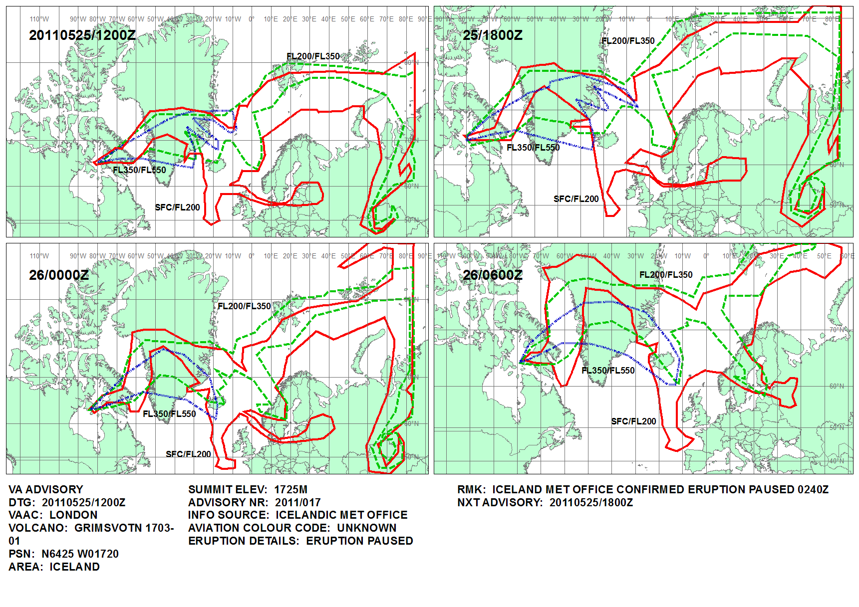
On 21 May 2011 at 19:25 UTC, an eruption began, with 12 km (7 mi) high plumes accompanied by multiple earthquakes,[12][13][14][15] Until 25 May, the eruption scale had been larger than that of the 2010 eruption of Eyjafjallajökull.
The ash cloud from the eruption rose to 20 km (12 mi), and was so far 10 times larger than the 2004 eruption, and the strongest in Grímsvötn in the last 100 years.[16]

Disruption to air travel in Iceland[17] commenced on 22 May, followed by Greenland, Scotland,[18] Norway, Svalbard[19] and a small part of Denmark on subsequent days. On 24 May the disruption spread to Northern Ireland and to airports in northern England.[17] The cancellation of 900 out of 90,000 European flights[20] in the period 23–25 May was much less widespread than the 2010 disruption after the Eyjafjallajökull eruption.
The eruption stopped at 02:40 UTC on 25 May 2011, although there was some explosive activity from the eruptive vents affecting only the area around the crater.[21][22][23]
2020 onward threats of eruption[edit]
In June 2020, the Icelandic Meteorological Office (IMO) issued a warning that an eruption might take place in the coming weeks or months, following scientists reporting high levels of sulfur dioxide, which is indicative of the presence of shallow magma. IMO warned that a glacial flood as a result of melting ice could trigger an eruption.[24] No eruption occurred.
In September 2021, an increase in water outflow from under the Vatnajökull ice cap was reported. The water contains elevated levels of dissolved hydrogen sulfide, suggesting increased volcanic activity under the ice.[25] Jökulhlaup (glacial lake flooding) can occur before or after an eruption.
On 4 December 2021, a jökulhlaup occurred from Grímsvötn into the Gígjukvísl river, with an average flow of 2,600 m3/s (92,000 cu ft/s). Two days later, the Icelandic Meteorological Office increased the alert level for Grímsvötn from yellow to orange, after a series of earthquakes was detected. On 7 December, the alert level was lowered back to yellow, after seismic activity decreased and no signs of eruptive activity were detected.[26]
On 11 December 2023, a jökulhlaup followed in time,[7] a Mw4.5 earthquake.[27]
Eruption history before 1990[edit]
Tephra studies on soil samples from around the Vatnajökull ice-cap, show that the Grímsvötn volcanic system has high activity for Iceland, and had between 4 to 14 explosive eruptions every 100 years (mean about 7 eruptions every 100 years) between 7600 years ago and 870 AD.[28] For technical reasons only the last 10,200 years of explosive eruptions have been characterised locally,[29] and the record gets more inaccurate with time especially prior to 1598, which is first eruption timed to the day.[1] The Laki eruptions which were both effusive and explosive between June 1783 and February 1784,[30] produced the Skaftáreldahraun lava flows, which cover a large part of south-east Iceland.[3]. Before this the tip of the Rauðhólar-Eldgígur fissure system was active with the production of the 4550 BCE Botnahraun lava flow which extends beyond the furtherest extent to the south of the Laki lava field.[3] The Rauðhólar-Eldgígur fissure system also formed the Núpahraun lava flows around 4000 BP[30] that extend from the Vatnajökull glacier towards the south east coast and are covered in part by the northern Laki Skaftáreldahraun lava flow.[3] There are two recent pre-historic but undated Bergvatnsárhraun lava flows just on the south-eastern edge of the Vatnajökull glacier, related to the line of the Rauðhólar-Eldgígur fissures.[3]
| Date Cal BP | Standard Date | Lake Lögurinn tephra thickness | VEI/Comment |
|---|---|---|---|
| - | 2011 | - | VEI 4.[1] |
| - | 2004 | - | VEI 3.[1] |
| - | 1998 | - | VEI 3.[1] |
| - | 1996 | - | VEI 3.[1] |
| - | 1983 | - | VEI 2.[1] |
| - | 1954 | - | VEI 1.[1] |
| 12 | 1938 | - | VEI 4.[1] |
| 16 | 1934 | - | VEI 2.[1] |
| 17 | 1933 | - | VEI 1.[1] |
| 28 | 1922 | 9 cm (3.5 in) | VEI 2[1],Lake Lögurinn core.[29] |
| 31 | 1919 | - | VEI 2.[1] |
| 40 | 1910 | - | [1] |
| 53 | 1897 | - | VEI 2.[1] |
| 67 | 1883 | - | VEI 2.[1] |
| 77 | 1873 | - | VEI 4.[1] |
| 83 | 1867 | - | VEI 1.[1] |
| 96 | 1854 | - | VEI 2.[1] |
| 112 | 1838 | - | VEI 2.[1] |
| 134 | 1816 | - | VEI 2.[1] |
| 167 | 1783 | - | VEI 4.[1] Laki eruption. |
| 176 | 1774 | - | VEI 2.[1] |
| 182 | 1768 | - | VEI 2.[1] |
| 197 | 1753 | - | VEI 2.[1] |
| 220 | 1730 | - | VEI 2.[1] |
| 225 | 1725 | - | VEI 2.[1] |
| 234 | 1716 | - | VEI 2.[1] |
| 244 | 1706 | - | VEI 2.[1] |
| 253 | 1697 | - | [1] |
| 266 | 1684 | - | VEI 2.[1] |
| 269 | 1681 | - | [1] |
| 285 | 1665 | 7 cm (2.8 in) | [1]Approx 280 BP eruption Lake Lögurinn core.[29] |
| 291 | 1659 | - | VEI 2.[1] |
| 312 | 1638 | - | VEI 2.[1] |
| 318 | 1632 | - | [1] |
| 321 | 1629 | - | VEI 2.[1] |
| 328 | 1622 | - | [1] |
| 331 | 1619 | - | VEI 2[1] |
| 340 | 1610 | - | [1] |
| 347 | 1603 | 2 cm (0.79 in) | Approx 345 BP eruption - Oct 1603 Lake Lögurinn core[29] |
| 352 | 1598 | - | VEI 3[1] |
| 420±10 | 1530±10 | - | [1] |
| 429 | 1521 | - | [1] |
| 440 | 1510 | - | Lake Lögurinn core.[29] |
| 442 | 1508 | 8 cm (3.1 in) | Lake Lögurinn core.[29] |
| 450 | 1500 | - | Lake Lögurinn core.[29] |
| 450 | 1500 | - | [1] |
| 460±10 | 1490±10 | - | [1] |
| 479 | 1471 | - | [1] |
| 480±10 | 1470±10 | - | [1] |
| 481 | 1469 | - | [1] |
| 500±10 | 1450±10 | - | [1] |
| 520±10 | 1430±10 | - | [1] |
| 560±10 | 1390±10 | - | [1] |
| 580±10 | 1370±10 | - | [1] |
| 581 | 1369 | - | [1] |
| 596 | 1354 | - | Lake Lögurinn, Kárahnjúkar & Snæfell cores.[29][1] |
| 600 | 1350 | - | [1] |
| 609 | 1341 | - | VEI 2.[1] |
| 618 | 1332 | - | VEI 2.[1] |
| 640±10 | 1310±10 | - | [1] |
| 660±10 | 1290±10 | - | [1] |
| 680±10 | 1270±10 | - | [1] |
| 720±10 | 1230±10 | - | [1] |
| 760 | 1190 | - | [1] |
| 788 | 1162 | 5 cm (2.0 in) | Lake Lögurinn, Kárahnjúkar & Snæfell cores.[29] |
| 860 | 1090 | - | [1] |
| 900 | 1050 | 5 cm (2.0 in) | Lake Lögurinn, Kárahnjúkar & Snæfell cores.[29] |
| 940 | 1010 | - | [1] |
| 973 | 977 | 5 cm (2.0 in) | Lake Lögurinn core. Has some Veidivötn-Bárdarbunga compositional characteristics - may be mixed eruption or mis–assigned.[29] |
| 1065 | 885 | - | Lake Lögurinn, Kárahnjúkar & Snæfell cores.[29] |
| 1092 | 858 | 9 cm (3.5 in) | Lake Lögurinn & Kárahnjúkar cores.[29] |
| 1097 | 853 | 3 cm (1.2 in) | Lake Lögurinn & Kárahnjúkar cores.[29] |
| 1098 | 852 | 5 cm (2.0 in) | Lake Lögurinn, Kárahnjúkar & Snæfell cores.[29] |
| 1100 | 850 | 2 cm (0.79 in) | Lake Lögurinn core. Has also Kverkfjöll, Veidivötn-Bárdarbunga compositional characteristics - may be mixed eruption or mis–assigned.[29] |
| 1162 | 788 | 2 cm (0.79 in) | Lake Lögurinn, Kárahnjúkar & Snæfell cores.[29] |
| 1448 | 502 | 9 cm (3.5 in) | Lake Lögurinn, Kárahnjúkar cores.[29] |
| 1647 | 303 | 5 cm (2.0 in) | Lake Lögurinn core.[29] |
| 1670 | 280 | 4 cm (1.6 in) | Lake Lögurinn, Kárahnjúkar, Snæfell, Svartárkort & marine cores.[29] |
| 1734 | 216 | 6 cm (2.4 in) | Lake Lögurinn, Kárahnjúkar & Snæfell cores.[29] |
| 1767 | 183 | 1 cm (0.39 in) | Lake Lögurinn core.[29] |
| 1968±100 | 18 BCE | 3 cm (1.2 in) | VEI 2[1]Lake Lögurinn core. Has some Veidivötn-Bárdarbunga compositional characteristics - may be mixed eruption or mis–assigned [29] |
| 2539 | 589 BCE | 7 cm (2.8 in) | Lake Lögurinn core.[29] |
| 2750 | 800 BCE | 4 cm (1.6 in) | Lake Lögurinn, Kárahnjúkar, Snæfell & marine cores.[29] |
| 2784 | 834 BCE | 9 cm (3.5 in) | Lake Lögurinn, Kárahnjúkar, Snæfell & marine cores.[29] |
| 3900 | 1950 BCE | - | VEI 2.[1] |
| 4356 | 2406 BCE | 4 cm (1.6 in) | Lake Lögurinn & Kárahnjúkar cores.[29] |
| 4651 | 2701 BCE | 1 cm (0.39 in) | Lake Lögurinn, Kárahnjúkar & Snæfell cores.[29] |
| 5293 | 3343 BCE | 9 cm (3.5 in) | Lake Lögurinn core. Has some Kverkfjöll compositional characteristics - may be mixed eruption or mis–assigned.[29] |
| 5557 | 3607 BCE | 5 cm (2.0 in) | Lake Lögurinn core.[29] |
| 5661 | 3711 BCE | 4 cm (1.6 in) | Lake Lögurinn & Snæfell cores.[29] |
| 5695 | 3745 BCE | 7 cm (2.8 in) | Lake Lögurinn, Kárahnjúkar & Snæfell cores. Has some Veidivötn-Bárdarbunga compositional characteristics - may be mixed eruption or mis–assigned.[29] |
| 6067 | 4117 BCE | 7 cm (2.8 in) | Lake Lögurinn, Kárahnjúkar, Snæfell & marine cores.[29] |
| 6137 | 4187 BCE | 1 cm (0.39 in) | Lake Lögurinn core. Trace possible in a Kárahnjúkar core.[29] |
| 6226 | 4276 BCE | 7 cm (2.8 in) | Lake Lögurinn. Possibly in a Kárahnjúkar core.[29] |
| 6283 | 4333 BCE | 7 cm (2.8 in) | Lake Lögurinn core. Possibly in a Kárahnjúkar core.[29] |
| 6288 | 4338 BCE | 2 cm (0.79 in) | Lake Lögurinn. Trace possible in a Kárahnjúkar core.[29] |
| 6624 | 4674 BCE | - | Lake Lögurinn & Kárahnjúkar cores.[29] |
| 6688 | 4738 BCE | 8 cm (3.1 in) | Lake Lögurinn & Kárahnjúkar cores.[29] |
| 6799 | 4849 BCE | 7 cm (2.8 in) | Lake Lögurinn & Kárahnjúkar cores.[29] |
| 7023 | 5073 BCE | 6 cm (2.4 in) | Lake Lögurinn, Kárahnjúkar & Svartárkort cores.[29] |
| 7708 | 5758 BCE | 3 cm (1.2 in) | Lake Lögurinn & Kárahnjúkar cores.[29] |
| 7780 | 5830 BCE | - | Lake Lögurinn core.[29] |
| 7839 | 5889 BCE | 2 cm (0.79 in) | Lake Lögurinn & Kárahnjúkar cores.[29] |
| 8176 | 5889 BCE | 1 cm (0.39 in) | Lake Lögurinn core.[29] |
| 8642 | 6692 BCE | 6 cm (2.4 in) | Lake Lögurinn core.[29] |
| 8645 | 6695 BCE | 9 cm (3.5 in) | Lake Lögurinn core a possibly in Svartárkort core.[29] |
| 8666 | 6716 BCE | 2 cm (0.79 in) | Lake Lögurinn core.[29] |
| 8826 | 6876 BCE | 2 cm (0.79 in) | Lake Lögurinn core.[29] |
| 9058 | 7108 BCE | 9 cm (3.5 in) | Lake Lögurinn core.[29] |
| 9086 | 7136 BCE | 8 cm (3.1 in) | Lake Lögurinn core.[29] |
| 9112 | 7162 BCE | 6 cm (2.4 in) | Lake Lögurinn core.[29] |
| 9121 | 7171 BCE | 6 cm (2.4 in) | Lake Lögurinn & Svartárkort cores.[29] |
| 9130 | 7180 BCE | 5 cm (2.0 in) | Lake Lögurinn & Svartárkort cores[29] |
| 9184 | 7234 BCE | 3 cm (1.2 in) | Lake Lögurinn core.[29] |
| 9268 | 7318 BCE | 5 cm (2.0 in) | Lake Lögurinn core.[29] |
| 9344 | 7394 BCE | 3 cm (1.2 in) | Has some Veidivötn-Bárdarbunga compositional characteristics - may be mixed eruption or mis–assigned. Lake Lögurinn & Snæfell cores[29] |
| 9433 | 7483 BCE | 8 cm (3.1 in) | Lake Lögurinn core. Possibly in Snæfell core[29] |
| 9486 | 7536 BCE | 4 cm (1.6 in) | Lake Lögurinn core.[29] |
| 9527 | 7577 BCE | 8 cm (3.1 in) | Lake Lögurinn core.[29] |
| 9535 | 7585 BCE | 6 cm (2.4 in) | Lake Lögurinn core.[29] |
| 9653 | 7703 BCE | 2 cm (0.79 in) | Lake Lögurinn core.[29] |
| 9776 | 7826 BCE | 2 cm (0.79 in) | Lake Lögurinn & Svartárkort cores[29] |
| 9849 | 7899 BCE | - | Lake Lögurinn & Kirkjugardur cores.[29] |
| 9869 | 7919 BCE | 1 cm (0.39 in) | Lake Lögurinn, Svartárkort & Kirkjugardur cores[29] |
| 10003 | 8053 BCE | 6 cm (2.4 in) | Lake Lögurinn core.[29] |
| 10019 | 8069 BCE | 5 cm (2.0 in) | Lake Lögurinn, Svartárkort & Kirkjugardur cores[29] |
| 10198 | 8248 BCE | - | Lake Lögurinn, Kirkjugardur cores.[29] |
| 10200 | 8250 BCE | - | VEI 6[1]Also has some Borrobol tephra like compositional characteristics - may be mixed eruption or mis–assigned. Lake Lögurinn, Svartárkort, Litligardur & Reitsvík cores and may be the Fosen tephra identified of same age in Fosen, Norway[29] |
Bacteria in the subglacial lakes[edit]
In 2004, a community of bacteria was detected in water of the Grímsvötn lake under the glacier, the first time that bacteria have been found in a subglacial lake. The lakes never freeze because of the volcanic heat. The bacteria can also survive at low concentrations of oxygen. The site is a possible analogue for life on the planet Mars, because there are also traces of volcanism and glaciers on Mars and thus the findings could help identify how to look for life on Mars.[31][32]
Geology[edit]
There is the potential for mechanical interaction such as dyke propagation between Grímsvötn and Thordarhyrna.[33] Interactions can also occur with the nearby Bárðarbunga volcano, which is part of a separate volcanic system.[33] The volcano erupts predominantly tholeiitic basalt, [3] and a close chemical affinity exists with the other lavas of the Grímsvötn-Laki volcanic system.[34] Some of the tephra's erupted have transpired to have mixed compositions with nearby volcanic systems and it is not known if this is due to dual eruptions or intusions crossing magma reserviors.[29] It is part of the Eastern volcanic zone of Iceland, and is directly over the Iceland mantle plume.[35] The volcanic system has crater rows extending to the south east; the 25 km (16 mi) long Laki–Grímsvötn fissure system and the 30 km (19 mi) long Rauðhólar-Eldgígur fissure system.[34][3][5]
Future trends[edit]
Studies indicate that volcanic activity in Iceland rises and falls so that the frequency and size of eruptions in and around the Vatnajökull ice cap varies with time. It is believed that the four eruptions between 1996 and 2011 could mark the beginning of an active period, during which an eruption in Grímsvötn in Vatnajökull may be expected every 2–7 years. Parallel volcanic activity in nearby Bárðarbunga is known to be associated with increased activity in Grímsvötn. Seismic activity has been increasing in the area in recent years, indicating the entry of magma.[36]
See also[edit]
- Geography of Iceland
- Glacial lake outburst flood
- Iceland hotspot
- Iceland plume
- List of glaciers of Iceland
- List of islands of Iceland
- List of lakes of Iceland
- Plate tectonics
- Timeline of volcanism on Earth
- Volcanism of Iceland
References[edit]
- ^ a b c d e f g h i j k l m n o p q r s t u v w x y z aa ab ac ad ae af ag ah ai aj ak al am an ao ap aq ar as at au av aw ax ay az ba bb bc bd be bf bg bh bi bj bk bl bm bn bo bp "Grímsvötn". Global Volcanism Program. Smithsonian Institution. Retrieved 27 April 2024.
- ^ "How to pronounce /grímsvötn/". youtube.com. Retrieved 23 May 2011.
- ^ a b c d e f g Guðmundsson, Magnús T.; Larsen, Guðrún (2019). "Grímsvötn Alternative name: Grímsvötn-Laki". Retrieved 31 March 2024.
- ^ Jude-Eton, T. C.; Thordarson, T.; Gudmundsson, M. T.; Oddsson, B. (2012-03-08). "Dynamics, stratigraphy and proximal dispersal of supraglacial tephra during the ice-confined 2004 eruption at Grímsvötn Volcano, Iceland". Bulletin of Volcanology. 74 (5): 1057–1082. Bibcode:2012BVol...74.1057J. doi:10.1007/s00445-012-0583-3. ISSN 0258-8900. S2CID 128678427.
- ^ a b Guðmundsson, Magnús T.; Larsen, Guðrún (2019). "Þórðarhyrna central volcano (Grímsvötn-Laki volcanic system) e: Thordarhyrna". Retrieved 31 March 2024.
- ^ Andrew, R. E. B. (2008). PhD Dissertation: Volcanotectonic Evolution and Characteristic Volcanism of the Neovolcanic Zone of Iceland (PDF) (Thesis). Georg-August-Universität, Göttingen. pp. 1–122. Archived from the original (PDF) on 2012-03-09. Retrieved 2011-05-24. : pages 38,39, Jökulhlaup figure 8.1
- ^ a b c d e "Flood tremor gradually increasing". 12 January 2023. Retrieved 13 January 2023.
- ^ Russell, Andrew J.; Gregory, Andrew R.; Large, Andrew R. G.; Fleisher, P. Jay; Harris, Timothy D. (2007). "Tunnel channel formation during the November 1996 jökulhlaup, Skeiðarárjökull, Iceland". Annals of Glaciology. 45 (1): 95–103. Bibcode:2007AnGla..45...95R. doi:10.3189/172756407782282552.
- ^ See eg.: Elín Margrét Magnúsdóttir: Gjóska úr Grímsvötnum 2011 og Bárðarbungu 2014-2015 : Ásýndar- ogkornastærðargreining. BS ritgerð. Jarðvísindadeild Háskóli Íslands (2017) (in Icelandic, abstract also in English) Retrieved 24 August 2020.
- ^ See also: Anne Schöpa: Subglacial volcanism with examples from Iceland. TU Freiberg. (2008)
- ^ "Possible Harmonic tremor pulse at Grímsfjall volcano | Iceland Volcano and Earthquake blog". Jonfr.com. 2010-10-02. Archived from the original on 2010-10-10. Retrieved 22 May 2011.
- ^ Eldgos í Grímsvötnum Archived 2011-08-03 at the National and University Library of Iceland, 24 May 2011 (in Icelandic)
- ^ Njörður Helgason (14 April 2011). "Vegurinn um Skeiðarársand lokaður". mbl.is. Retrieved 22 May 2011.
- ^ "Iceland's most active volcano erupts – Europe". Al Jazeera English. 21 May 2011. Retrieved 22 May 2011.
- ^ "Iceland volcanic eruption 'not linked to the end of the world' | IceNews – Daily News". Icenews.is. Archived from the original on 24 May 2011. Retrieved 22 May 2011.
- ^ "Largest Volcanic Eruption in Grímsvötn in 100 Years". Daily News. Iceland Review Online. 22 May 2011. Archived from the original on 24 May 2011. Retrieved 22 May 2011.
- ^ a b Eurocontrol news
- ^ Scottish flights grounded by Iceland volcanic ash cloud, BBC, 23 May 2011
- ^ Iceland eruption hits Norwegian flights, The Foreigner, 23 May 2011
- ^ David Learmount (26 May 2011). "European proceedures (sic) cope with new ash cloud". Flightglobal. Archived from the original on July 3, 2015. Retrieved September 28, 2015.
- ^ "Volcanic Ash Advisory at 1241 on 25 May 2011". Met Office UK. Retrieved 25 May 2011.
- ^ "Iceland volcano ash: German air traffic resuming". BBC News. 25 May 2011. Retrieved 25 May 2011.
- ^ "Update on volcanic activity in Grímsvötn". Iceland Met Office. Retrieved 27 May 2011.
- ^ "Evidences that Grímsvötn volcano is getting ready for the next eruption | News". Icelandic Meteorological office. Retrieved 2020-08-05.
- ^ "Grimsvötn volcano (Iceland): subglacial meltwater flood in progress". Volcano Discovery. 3 September 2021. Retrieved 9 September 2021.
- ^ "IWO:Flood in Grímsvötn". 8 December 2021. Retrieved 13 January 2023.
- ^ "UGS:M 4.5 - 109 km W of Höfn, Iceland". Retrieved 13 January 2023.
- ^ Óladóttir, B.A.; Larsen, G.; Sigmarsson, O. (2011). "Holocene volcanic activity at Grímsvötn, Bárdarbunga and Kverkfjöll subglacial centres beneath Vatnajökull, Iceland". Bulletin of Volcanology. 73: 1187–1208. Bibcode:2011BVol...73.1187O. doi:10.1007/s00445-011-0461-4.: 1187
- ^ a b c d e f g h i j k l m n o p q r s t u v w x y z aa ab ac ad ae af ag ah ai aj ak al am an ao ap aq ar as at au av aw ax ay az ba bb bc bd be bf bg bh bi bj bk bl bm bn bo bp bq br Gudmundsdóttir, E.R.; Larsen, G.; Björck, S.; Ingólfsson, Ó; Striberger, J. (2016). "A new high-resolution Holocene tephra stratigraphy in eastern Iceland: Improving the Icelandic and North Atlantic tephrochronology". Quaternary Science Reviews. 150: 234–249. doi:10.1016/j.quascirev.2016.08.011.: Table 4
- ^ a b Bindeman, I.; Gurenko, A.; Sigmarsson, O.; Chaussidon, M. (2008). "Oxygen isotope heterogeneity and disequilibria of olivine crystals in large volume Holocene basalts from Iceland: evidence for magmatic digestion and erosion of Pleistocene hyaloclastites". Geochimica et Cosmochimica Acta. 72 (17): 4397–4420. Bibcode:2008GeCoA..72.4397B. doi:10.1016/j.gca.2008.06.010.
- ^ Gaidos, E; Lanoil, B; Thorsteinsson, T; Graham, A; Skidmore, M; Han, SK; Rust, T; Popp, B (2004). "A viable microbial community in a subglacial volcanic crater lake, Iceland". Astrobiology. 4 (3): 327–44. doi:10.1089/1531107041939529. PMID 15383238.
- ^ Peplow, Mark (2004). "Glacial lake hides bacteria". Nature. doi:10.1038/news040712-6.
- ^ a b Gudmundsson, A.; Andrew, R.E. (2007). "Mechanical interaction between active volcanoes in Iceland". Geophysical Research Letters. 34 (10): L10310. Bibcode:2007GeoRL..3410310G. doi:10.1029/2007GL029873.
- ^ a b Manning, C.J.; Thirlwall, M.F. (2014). "Isotopic evidence for interaction between Öræfajökull mantle and the Eastern Rift Zone, Iceland". Contributions to Mineralogy and Petrology. 167: 1–22. Bibcode:2014CoMP..167..959M. doi:10.1007/s00410-013-0959-1.: 958
- ^ Andrew, Ruth E. B.; Gudmundsson, Agust (20 November 2008). "Volcanoes as elastic inclusions: their effects on the propagation of dykes, volcanic fissures, and volcanic zones in Iceland". Journal of Volcanology and Geothermal Research. Volcanic Flows and Falls. 177 (4). Elsevier: 1045–1054. doi:10.1016/j.jvolgeores.2008.07.025.: 4. Mechanical interaction
- ^ "Icelandic Met Office on 1 September 2011". Icelandic Met Office. Retrieved 2 September 2011.
External links[edit]
- Grímsvötn Archived 2017-02-04 at the Wayback Machine in the Catalogue of Icelandic Volcanoes
- Update on Grímsvötn Activity – from the Icelandic Met Office and University of Iceland (updated at least daily)
- Current seismology around Grímsvötn – Earthquakes in last 48 hours
- BBC news report of the 23 May 2011 eruption
- Report on the 2011 start of the Grímsvötn eruption from the Icelandic Met Office
- Official Website of Vatnajökull National Park
| International | |
|---|---|
| Geographic | |