Ouham River
| Ouham River Bahr Sarh; Bahr Sara | |
|---|---|
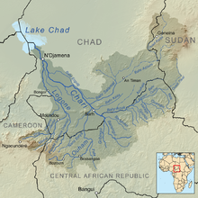
 Map showing the Chari with the Ouham (Bottom center) | |
| Location | |
| Countries | |
| Cities | |
| Physical characteristics | |
| Source | |
| • location | Central African Republic |
| • coordinates | 6°11′N 15°14′E / 6.183°N 15.233°E |
| • elevation | 1,139 m (3,737 ft) |
| Mouth | |
• location | Chari River north from Sarh, Chad |
• coordinates | 9°18′59″N 18°13′35″E / 9.31639°N 18.22639°E |
• elevation | 364 m (1,194 ft) |
| Length | 676 km (420 mi) |
| Basin size | 70,000 km2 (27,000 sq mi) |
| Discharge | |
| • average | 480 m3/s (17,000 cu ft/s) |
| Basin features | |
| Tributaries | |
| • left | Nana Barya |
| • right | Fafa |
The Ouham River is a river in Central Africa, and one of the main headwaters of the Chari River. The Ouham originates in the Central African Republic between the prefecture Nana-Mambéré and the prefecture Ouham-Pendé, crossing into Chad where it joins the Chari about 25 km north Sarh. Tributaries are Baba, Fafa, Nana Bakassa, Nana Barya.
Hydrometry[edit]
The flow of the river observed over 33 years (1951–84) in Moïssala a town in Chad about 150 km above the mouth of the Chari.[1] The at Moïssala observed average annual flow during this period was 480 m³ / s fed by an area of about 67,600 km 2 approximately 95% of the total catchment area of the River.
The average monthly flow of the river Sara at hydrological station of Moïssala (in m³ / s ) (Calculated using the data for a period of 33 years, 1951–84)

See also[edit]
References[edit]
