Gunter, Texas
Gunter, Texas | |
|---|---|
| Motto: "Tough People Win"[1] | |
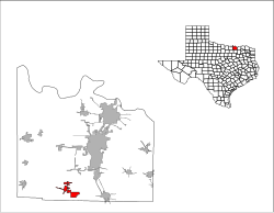
 Location of Gunter, Texas | |
 | |
| Coordinates: 33°27′5″N 96°44′40″W / 33.45139°N 96.74444°W | |
| Country | United States |
| State | Texas |
| County | Grayson |
| Area | |
| • Total | 17.70 sq mi (45.85 km2) |
| • Land | 17.59 sq mi (45.56 km2) |
| • Water | 0.11 sq mi (0.29 km2) |
| Elevation | 705 ft (215 m) |
| Population (2020) | |
| • Total | 2,060 |
| • Density | 95.22/sq mi (36.77/km2) |
| Time zone | UTC-6 (Central (CST)) |
| • Summer (DST) | UTC-5 (CDT) |
| ZIP code | 75058 |
| Area code | 903 |
| FIPS code | 48-31616[3] |
| GNIS feature ID | 1373952[4] |
| Website | ci |
Gunter is a city in the southwestern corner of Grayson County, Texas, United States. The population was 2,060 at the 2020 census,[5] up from 1,498 at the 2010 census. It is part of the Sherman–Denison metropolitan area.
History[edit]
Gunter was founded in 1902 (other sources report 1901, with a post office as early as 1898) when the family of John (a/k/a Jot) Gunter deeded 328 acres (1.33 km2) for the original townsite, near the intersection of current State Highway 289 and Farm to Market Road 121. The first residence was established in 1903 by Albert Earthman, who would later charter the First National Bank in Gunter. A second bank, the First State Bank, would later open.
Gunter steadily grew until 1924, when the First State Bank (having outlasted the First National Bank) closed, leaving many businesses and farmers in financial ruin. The Great Depression and two devastating fires in 1930 and 1948 further damaged the local economy.
Gunter began to increase its population in the 1950s, and experienced its greatest growth, at 37 percent, during the 1990s. Gunter has started to experience overflow growth from the northern Metroplex suburbs, due to its location on State Highway 289 approximately 10 miles (16 km) north of Celina, as well as its proximity to the Sherman-Denison metropolitan area and nearby Lake Texoma. In May 2002, a branch of Ada, Oklahoma-based Landmark Bank (now part of Simmons Bank) opened in Gunter, providing the town its first financial institution in nearly 90 years.
Geography[edit]
Gunter is located in southwestern Grayson County. State Highway 289 leads north 18 miles (29 km) to Sherman, the county seat, and south 10 miles (16 km) to Celina.
The city's boundaries expanded between 2000 and 2010. According to the United States Census Bureau, the city had a total area of 1.5 square miles (3.9 km2), all land, in 2000, which had increased to 17.6 square miles (45.7 km2) in 2010, of which 17.5 square miles (45.4 km2) were land and 0.1 square miles (0.3 km2), or 0.63%, were water.[5]
Climate[edit]
The climate in this area is characterized by hot, humid summers and generally mild to cool winters. According to the Köppen Climate Classification system, Gunter has a humid subtropical climate, abbreviated "Cfa" on climate maps.[6]
Demographics[edit]
| Census | Pop. | Note | %± |
|---|---|---|---|
| 1920 | 575 | — | |
| 1930 | 475 | −17.4% | |
| 1940 | 481 | 1.3% | |
| 1950 | 463 | −3.7% | |
| 1960 | 593 | 28.1% | |
| 1970 | 647 | 9.1% | |
| 1980 | 849 | 31.2% | |
| 1990 | 898 | 5.8% | |
| 2000 | 1,230 | 37.0% | |
| 2010 | 1,498 | 21.8% | |
| 2020 | 2,060 | 37.5% | |
| U.S. Decennial Census[7] | |||
| Race | Number | Percentage |
|---|---|---|
| White (NH) | 1,403 | 68.11% |
| Black or African American (NH) | 31 | 1.5% |
| Native American or Alaska Native (NH) | 25 | 1.21% |
| Asian (NH) | 18 | 0.87% |
| Some Other Race (NH) | 7 | 0.34% |
| Mixed/Multi-Racial (NH) | 125 | 6.07% |
| Hispanic or Latino | 451 | 21.89% |
| Total | 2,060 |
As of the 2020 United States census, there were 2,060 people, 495 households, and 413 families residing in the city.
Government[edit]
Gunter is led by a six-person City Council, consisting of the Mayor and five members, all of which are elected at-large.
On December 12, 2023, all five of the at-large members resigned from their positions (and failed to appear at a scheduled City Council meeting the following night), leaving the Mayor as the only remaining member.[11]
Education[edit]
Students are served by the Gunter Independent School District.[12]
References[edit]
- ^ "Official Website for the City of Gunter Texas". Official Website for the City of Gunter Texas. Retrieved October 19, 2012.
- ^ "2019 U.S. Gazetteer Files". United States Census Bureau. Retrieved August 7, 2020.
- ^ "U.S. Census website". United States Census Bureau. Retrieved January 31, 2008.
- ^ "US Board on Geographic Names". United States Geological Survey. October 25, 2007. Retrieved January 31, 2008.
- ^ a b "Geographic Identifiers: 2010 Demographic Profile Data (G001): Gunter city, Texas". American Factfinder. U.S. Census Bureau. Retrieved March 21, 2017.[dead link]
- ^ Climate Summary for Gunter, Texas
- ^ "Census of Population and Housing". Census.gov. Retrieved June 4, 2015.
- ^ "Explore Census Data". data.census.gov. Retrieved May 22, 2022.
- ^ https://www.census.gov/ [not specific enough to verify]
- ^ "About the Hispanic Population and its Origin". www.census.gov. Retrieved May 18, 2022.
- ^ "MSN". MSN.
- ^ "Gunter Independent School District". Gunter Independent School District. Retrieved October 19, 2012.
External links[edit]
- City of Gunter official website
- Handbook of Texas Online article
- Gunter Area Chamber of Commerce Archived 2013-01-25 at archive.today
- City-Data.com

