
Oirschot
Oirschot | |
|---|---|
 Former city hall of Oirschot | |
 Flag Coat of arms | |
.svg) Location in North Brabant | |
| Coordinates: 51°30′N 5°18′E / 51.500°N 5.300°E | |
| Country | Netherlands |
| Province | North Brabant |
| Government | |
| • Body | Municipal council |
| • Mayor | Judith Keijzers-Verschelling (CDA) |
| Area | |
| • Total | 102.84 km2 (39.71 sq mi) |
| • Land | 101.78 km2 (39.30 sq mi) |
| • Water | 1.06 km2 (0.41 sq mi) |
| Elevation | 17 m (56 ft) |
| Population (January 2021)[4] | |
| • Total | 18,842 |
| • Density | 185/km2 (480/sq mi) |
| Demonym | Oirschottenaar |
| Time zone | UTC+1 (CET) |
| • Summer (DST) | UTC+2 (CEST) |
| Postcode | 5090–5091, 5688–5689 |
| Area code | 013, 0499 |
| Website | www |

Oirschot (Dutch pronunciation: [ˈoːrsxɔt] ⓘ; Orskot in the local dialect) is a municipality and a town in the southern Netherlands. It is situated 12 kilometres (7.5 mi) from the city of Eindhoven and 20 kilometres (12 mi) from the city of Tilburg in the province North Brabant (Noord-Brabant). The municipality had a population of 18,842 in 2021.
Population centres[edit]
- Oirschot
- Middelbeers
- Oostelbeers
- Spoordonk
- Westelbeers

Sights[edit]
There are more than 300 monuments in the municipality Oirschot.
Some of the monuments are:
- The Roman Catholic Church named Sint-Petrus’-Bandenkerk. This 15th- and 16th-century Gothic church is the biggest building in the town of Oirschot and the tower of the church is 73 meters high.
- The old town hall built in 1513 in the centre of town (Oirschot)
- Maria-church (Maria-kerk). A 12th-century Romanesque church in the centre of the town of Oirschot.
- Monastery Nazareth (Klooster Nazareth) with a chapel in Neoromanesque style (1910).
- Former Brewery De Kroon (Brouwerij de Kroon) built in 1773
- Hof van Solms, palace of Arnoldus Feij (or Arnold Fey)
- The Big Chair (De Grote Stoel) the biggest chair of Europe
- Huize Groenenberg, a house built in 1613
Some of the monuments outside of the town are:
- Chapel of the Holy Oak (Kapel van de Heilige Eik), stone chapel dated to 1854 built on the foundations of a stone chapel of 1606 (there was another stone chapel and a wooden chapel on the same location before the one of 1606). The chapel of 1606 was demolished by order of the States General in 1649 (Catholicism could not be practiced openly)
- The Old Tower (Oude Toren) of Oostelbeers, a church tower of the 14th century in a patch of forest surrounded by fields
- The Old Church of Middelbeers (Het Oude Kerkje - Oude Sint-Willibrorduskerk) - intact gothic rural church (15th century) typical for the region
- Maria Chapel (Mariakapel) of Westelbeers - chapel dating to 1637; it is a mystery why this chapel was not demolished during the 1640s or 1650s like nearly all other Catholic chapels in the region were
Events[edit]
- Zinderend Oirschot
- Countery & Western weekend
There are many more festivals in Oirschot every year.
Politics[edit]
City council[edit]
The municipal elections in March 2018 resulted in the following make-up of the City Council (17 seats in total):
- CDA: 4 seats
- De Gewone Man (local party): 4 seats
- Dorpsvisie (local party): 3 seats
- Sociaal Progressief Oirschot (local party): 3 seats
- VVD: 2 seats
- D66: 1 seats
The old 2014 coalition that was governing Oirschot was formed out of 4 parties: CDA, Socialist Party, Dorpsvisie and PvdA.
Mayor[edit]
The mayor of the municipality Oirschot is named Judith Keijzers-Verschelling. She is member of the political party CDA.
Notable people[edit]
- Arnold Fey, (Dutch Wiki) (born 1633 in Oirschot - 1679) a Dutch doctor.
- Frans van Lith (born 1863 in Oirschot - 1926) a Jesuit priest in Central Java
- Cornelius Van de Ven (1865 in Oirschot – 1932) Bishop of the Roman Catholic Diocese of Alexandria in Louisiana
- Carl Romme (1896 in Oirschot – 1980) a Dutch politician
- Michiel van Kempen (born 1957 in Oirschot) a Dutch writer, art historian and literary critic
- Anita Smits (born 1967 in Oirschot) a former archer who competed at the 1988 Summer Olympics
- Truus Smulders-Beliën (1902–1966), first female mayor in the Netherlands
- Sophie van Gestel (born 1991 in Oostelbeers) a Dutch beach volleyball player, participated in the 2012 Summer Olympics
Gallery[edit]
-
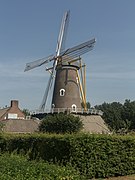 Oirschot, windmill: windmolen de Korenaar
 -
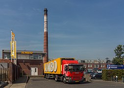 Oirschot, Jumbo supermarket
 -
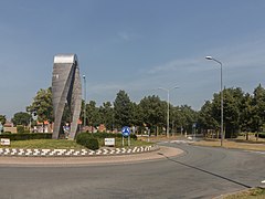 Oirschot, sculpture near de Sint Jorisstraat
 -
 Oostelbeers, tower: de Heilige Andreas en Antonius van Paduatoren
 -
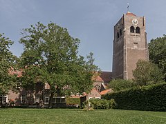 Spoordonk, church: de Bernadettekerk


References[edit]
- ^ "Samenstelling" [Members] (in Dutch). Gemeente Oirschot. Archived from the original on 14 July 2014. Retrieved 2 June 2014.
- ^ "Kerncijfers wijken en buurten 2020" [Key figures for neighbourhoods 2020]. StatLine (in Dutch). CBS. 24 July 2020. Retrieved 19 September 2020.
- ^ "Postcodetool for 5688AK". Actueel Hoogtebestand Nederland (in Dutch). Het Waterschapshuis. Retrieved 2 June 2014.
- ^ "Bevolkingsontwikkeling; regio per maand" [Population growth; regions per month]. CBS Statline (in Dutch). CBS. 1 January 2021. Retrieved 2 January 2022.
External links[edit]
Places adjacent to Oirschot | |
|---|---|

| International | |
|---|---|
| National | |
| Geographic | |