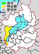
Shiga District, Shiga

Shiga (滋賀郡, Shiga-gun) was a district located in Shiga Prefecture, Japan.
As of 2003, the district has an estimated population of 21,964 and a density of 306.20 persons per km2. The total area is 71.73 km2.
History[edit]
- 1868 (Boshin War/Meiji Restoration) – The shogunate territories in the district become part of Ōtsu Prefecture (Ōtsu-ken)
- 1871 (Abolition of the han system) – All feudal domains (-han), including those containing territories in the district, become prefectures (-ken).
- 1871/72 – In the first wave of prefectural mergers, the entire district becomes part of Ōtsu Prefecture which is then renamed to Shiga after the district
- 1878/79 – The ancient districts of provinces are reactivated as modern administrative units as districts of prefectures: the district government of Shiga is established in Ōtsu-Hashimoto-chō (?, 大津橋本町)

- 1/4/1889 (establishment of municipalities & Great Meiji mergers) - The "Town and Village Code" (町村制, chō-son-sei), the new law establishing towns and villages as modern political units, was implemented. As a result, the town of Ōtsu and the villages of Shiga (滋賀村, Shiga-mura, "Shiga Village"), Zeze, Ishiyama, Sakamoto, Shimosakamoto, Ogoto, Katata, Ōgi, Mano, Ikadachi, Katsuragawa, Wani, Kido and Komatsu were formed.
- 1/4/1898 - The "District Code" (郡制, gun-sei), the revised law governing districts, was implemented, establishing indirectly elected district assemblies (gun-kai) and collective executive councils (gun-sanjikai).
- 1/10/1898 - Ōtsu Town (大津町, Ōtsu-chō) became [by definition of city: district-independent] Ōtsu City (大津市, Ōtsu-shi).
- 20/7/1901 -
- The village of Zeze became the town of Zeze.
- The village of Katata became the town of Katata.
- 1/4/1923 - The district assembly was abolished. The district office remains.
- 1/7/1926 - The district government was abolished, reducing the district (again) to a geographical division.
- 1/1/1930 - The village of Ishiyama became the town of Ishiyama.
- 10/5/1932 - The village of Shiga merged into the city of Ōtsu.
- 1/4/1951 - The towns of Zeze and Ishiyama merged with the city of Ōtsu into the new city of Ōtsu.
- 1950s (Great Shōwa mergers)
- 1/4/1955 - The town of Katata and the villages of Ōgi, Mano, Ikadachi and Katsuragawa merged into the town of Katata.
- 1/10/1955 - The villages of Wani, Kido and Komatsu merged into Shiga Town (志賀町, Shigachō).
- 30/9/1956 - Part of the town of Shiga (Kamogawa) merged into the town of Takashima from Takashima District.
- 1/4/1967 - The village of Katata merged into the city of Ōtsu.
- 20/3/2006 - The town of Shiga merged into the city of Ōtsu. Shiga District was dissolved as a result of this merger.
Transition[edit]
Light blue autonomies are Shiga District's town, deep blue autonomies are Shiga District's village, and gray autonomies are others.
| April 1, 1889 | 1889 - 1929 | 1930 - 1944 | 1945 - 1954 | 1955 - 1989 | 1990 - | Now | ||
|---|---|---|---|---|---|---|---|---|
| Ōtsu (大津) | October 1, 1898 Ōtsu City |
Ōtsu | April 1, 1933 Ōtsu |
Ōtsu | Ōtsu | Ōtsu | Ōtsu | |
| Shiga (滋賀) | Shiga | May 10, 1932 incorporation into Ōtsu | ||||||
| Zeze (膳所) | July 20, 1901 Zeze |
Zeze | ||||||
| Ishiyama (石山) | Ishiyama | January 1, 1930 Ishiyama | ||||||
| Sakamoto (坂本) | Sakamoto | Sakamoto | April 1, 1951 incorporation into Ōtsu | |||||
| Shimosakamoto (下阪本) | Shimosakamoto | Shimosakamoto | ||||||
| Ogoto (雄琴) | Ogoto | Ogoto | ||||||
| Katata (堅田) | July 20, 1901 Katata |
Katata | Katata | April 1, 1955 Katata |
April 1, 1967 incorporation into Ōtsu | |||
| Ōgi (仰木) | Ōgi | Ōgi | Ōgi | |||||
| Mano (真野) | Mano | Mano | Mano | |||||
| Ikadachi (伊香立) | Ikadachi | Ikadachi | Ikadachi | |||||
| Katsuragawa (葛川) | Katsuragawa | Katsuragawa | Katsuragawa | |||||
| Wani (和邇) | Wani | Wani | Wani | October 1, 1955 Shiga (志賀) |
March 20, 2006 incorporation into Ōtsu | |||
| Kido (木戸) | Kido | Kido | Kido | |||||
| Komatsu (小松) | Komatsu | Komatsu | Komatsu | |||||
