
Sado Island
You can help expand this article with text translated from the corresponding article in Japanese. (February 2022) Click [show] for important translation instructions.
|
Native name: 佐渡島 | |
|---|---|
 | |
 | |
| Geography | |
| Location | Japanese Archipelago |
| Coordinates | 38°04′03″N 138°23′51″E / 38.06750°N 138.39750°E |
| Area | 854.76[1] km2 (330.02 sq mi) |
| Highest elevation | 1,172 m (3845 ft) |
| Highest point | Mount Kinpoku |
| Administration | |
Sado Island (佐渡島, Sadogashima or Sadoshima) is an island located in the eastern part of the Sea of Japan, under the jurisdiction of Sado City, Niigata Prefecture, Japan, with a coastline of 262.7 kilometres (163.2 mi). In October 2017, Sado Island had a population of 55,212 people. Sado Island covers an area of 854.76 km2 (330.02 sq mi), and is the second largest island after Okinawa Island outside of the four main islands of Japan, excluding the disputed Southern Kurils.[1] The shortest distance between Sado Island and Honshu is 32 km (20 mi).[2] The highest peak on Sado Island is Mount Kinpoku, with an elevation of 1,172 m (3,845 ft).[3]
According to the international consensus, during World War II, the island was the site of forced labor. Around 1,500 Korean laborers were conscripted to work in difficult conditions in mines on the island. The Japanese government and some Japanese scholars deny that they were forced to work. In 2022, Japan filed to add the island to the UNESCO World Heritage Site list, which sparked international and domestic criticism.
Geography[edit]
The shape of Sado Island resembles the kanji character for ‘work’ (工) in Japanese or the letter ‘S’. The topography of the island can be roughly divided into three parts, the Ōsado range in the north, the Kosado range in the south, and the Kakakura plain with flat terrain in between. The Ōsado range area is higher in altitude, and the highest peak of Sado Island, Mount Kinpoku (1,172 m (3,845 ft) above sea level), is also located in this area. The coastline on the north side of Mount Sado is steep, and is a famous tourist spot, among which the Senkaku Bay is the most famous.[4] The Kosado range has a relatively flatter terrain with Satsuma orange and tea trees growing there. Its highest peak is Mount Ōjiyama, with an elevation of 646 m (2,119 ft).[5] The Nakakura Plain is a large plain in Japan's outlying islands and is also the agricultural area of Sado Island. On the west side of the Kuninaka Plain is Mano Bay, and on the east side is Ryōtsu Bay. The Kokufugawa River (also reads Konogawa River) flows through the Kuninaka Plain, with a total length of 19 km (12 mi), and flows into Mano Bay. Its watershed area accounts for 20% of Sado Island.[6] Lake Kamo, the largest lake in Niigata Prefecture, is located at the eastern end of the Kuninaka Plain. Lake Kamo was originally a freshwater lake, and later turned into a lagoon after an opening built to the Sea of Japan. Oyster breeding flourishes in the lake.[7] Part of Sado Island belongs to the Sado-Yahiko-Yoneyama Quasi-National Park.[8]
-
 Futatsugame Tombolo
 -
 Onogame
 -
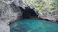 Kotoura Cave (Ryuodo Cave) in Ogi Coast
 -
 Senkaku Bay (Senkakuwan)
 -
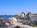 Nanaura Coast


.jpg)
Weather and climate[edit]
Affected by the warm Black Current that passes through the Sado waters, the winter in Sado Island is warmer than that in Niigata Prefecture and with less snow. In summer, due to the influence of ocean, the temperature difference between day and night is smaller than that of Niigata Prefecture, and is cooler than that of Niigata Prefecture. However, the Aikawa area on the northwestern side of the Ōsado range are affected by the monsoon blowing from the northwest and the temperature is higher. Precipitation on Sado Island is mainly concentrated in the end of the East Asian rainy season and early winter, and there is less precipitation than in Niigata Prefecture. When the low air pressure and typhoons pass through the Sea of Japan, Sado Island often suffers from Foehn wind, raising the temperature sharply. Located at the junction of the warm and cold current, Sado City enjoys diverse plants and rich aquatic resources.
| Climate data for Aikawa, Sado, Niigata, 1991−2020 normals, extremes 1911−present | |||||||||||||
|---|---|---|---|---|---|---|---|---|---|---|---|---|---|
| Month | Jan | Feb | Mar | Apr | May | Jun | Jul | Aug | Sep | Oct | Nov | Dec | Year |
| Record high °C (°F) | 17.0 (62.6) |
20.7 (69.3) |
22.3 (72.1) |
28.0 (82.4) |
30.0 (86.0) |
34.1 (93.4) |
37.4 (99.3) |
38.1 (100.6) |
37.4 (99.3) |
31.5 (88.7) |
26.3 (79.3) |
22.9 (73.2) |
38.1 (100.6) |
| Mean daily maximum °C (°F) | 6.5 (43.7) |
6.7 (44.1) |
9.6 (49.3) |
14.9 (58.8) |
19.9 (67.8) |
23.3 (73.9) |
27.1 (80.8) |
29.3 (84.7) |
25.9 (78.6) |
20.5 (68.9) |
15.0 (59.0) |
9.7 (49.5) |
17.4 (63.3) |
| Daily mean °C (°F) | 4.0 (39.2) |
4.0 (39.2) |
6.5 (43.7) |
11.1 (52.0) |
15.9 (60.6) |
19.8 (67.6) |
24.0 (75.2) |
26.0 (78.8) |
22.5 (72.5) |
17.2 (63.0) |
11.8 (53.2) |
6.8 (44.2) |
14.1 (57.4) |
| Mean daily minimum °C (°F) | 1.3 (34.3) |
1.0 (33.8) |
2.9 (37.2) |
7.2 (45.0) |
12.0 (53.6) |
16.6 (61.9) |
21.3 (70.3) |
22.9 (73.2) |
19.2 (66.6) |
13.6 (56.5) |
8.2 (46.8) |
3.8 (38.8) |
10.8 (51.5) |
| Record low °C (°F) | −7.5 (18.5) |
−7.4 (18.7) |
−6.4 (20.5) |
−2.1 (28.2) |
2.5 (36.5) |
7.6 (45.7) |
12.1 (53.8) |
14.6 (58.3) |
9.5 (49.1) |
4.4 (39.9) |
−2.8 (27.0) |
−6.6 (20.1) |
−7.5 (18.5) |
| Average precipitation mm (inches) | 131.1 (5.16) |
91.6 (3.61) |
96.6 (3.80) |
94.5 (3.72) |
97.3 (3.83) |
122.5 (4.82) |
207.3 (8.16) |
137.5 (5.41) |
139.9 (5.51) |
133.1 (5.24) |
154.8 (6.09) |
175.7 (6.92) |
1,581.9 (62.27) |
| Average snowfall cm (inches) | 28 (11) |
25 (9.8) |
4 (1.6) |
0 (0) |
0 (0) |
0 (0) |
0 (0) |
0 (0) |
0 (0) |
0 (0) |
0 (0) |
9 (3.5) |
66 (25.9) |
| Average rainy days | 19.7 | 15.3 | 14.0 | 10.3 | 9.7 | 9.0 | 10.9 | 8.7 | 10.4 | 12.3 | 16.6 | 20.9 | 157.8 |
| Average snowy days | 7.1 | 6.8 | 1.4 | 0 | 0 | 0 | 0 | 0 | 0 | 0 | 0 | 2.5 | 17.8 |
| Average relative humidity (%) | 69 | 68 | 66 | 67 | 72 | 78 | 81 | 77 | 73 | 69 | 68 | 69 | 71 |
| Mean monthly sunshine hours | 46.2 | 69.2 | 133.1 | 177.0 | 200.7 | 178.4 | 161.2 | 207.8 | 157.0 | 147.5 | 95.8 | 50.6 | 1,624.5 |
| Source 1: JMA[9] | |||||||||||||
| Source 2: JMA[10] | |||||||||||||
| Climate data for Cape Hajikizaki[a], 38°19.8′N 138°30.7′E / 38.3300°N 138.5117°E, 1991−2020 normals, extremes 1978−present | |||||||||||||
|---|---|---|---|---|---|---|---|---|---|---|---|---|---|
| Month | Jan | Feb | Mar | Apr | May | Jun | Jul | Aug | Sep | Oct | Nov | Dec | Year |
| Record high °C (°F) | 16.1 (61.0) |
22.4 (72.3) |
24.6 (76.3) |
28.0 (82.4) |
29.9 (85.8) |
30.0 (86.0) |
34.3 (93.7) |
35.0 (95.0) |
35.3 (95.5) |
29.7 (85.5) |
23.4 (74.1) |
18.7 (65.7) |
35.3 (95.5) |
| Mean daily maximum °C (°F) | 5.4 (41.7) |
5.8 (42.4) |
9.1 (48.4) |
14.2 (57.6) |
19.0 (66.2) |
22.4 (72.3) |
26.2 (79.2) |
28.2 (82.8) |
24.8 (76.6) |
19.5 (67.1) |
14.0 (57.2) |
8.5 (47.3) |
16.4 (61.6) |
| Daily mean °C (°F) | 3.1 (37.6) |
3.1 (37.6) |
5.7 (42.3) |
10.4 (50.7) |
15.1 (59.2) |
19.0 (66.2) |
23.1 (73.6) |
25.0 (77.0) |
21.8 (71.2) |
16.5 (61.7) |
11.0 (51.8) |
5.9 (42.6) |
13.3 (56.0) |
| Mean daily minimum °C (°F) | 0.7 (33.3) |
0.5 (32.9) |
2.5 (36.5) |
6.8 (44.2) |
11.4 (52.5) |
15.8 (60.4) |
20.5 (68.9) |
22.2 (72.0) |
18.9 (66.0) |
13.4 (56.1) |
7.9 (46.2) |
3.2 (37.8) |
10.3 (50.6) |
| Record low °C (°F) | −6.3 (20.7) |
−7.0 (19.4) |
−3.3 (26.1) |
−0.8 (30.6) |
2.1 (35.8) |
7.5 (45.5) |
12.3 (54.1) |
15.5 (59.9) |
9.5 (49.1) |
4.2 (39.6) |
−0.6 (30.9) |
−4.9 (23.2) |
−7.0 (19.4) |
| Average precipitation mm (inches) | 133.1 (5.24) |
94.3 (3.71) |
101.0 (3.98) |
104.1 (4.10) |
112.3 (4.42) |
127.2 (5.01) |
216.2 (8.51) |
154.0 (6.06) |
152.5 (6.00) |
161.1 (6.34) |
167.7 (6.60) |
180.9 (7.12) |
1,711.6 (67.39) |
| Average precipitation days (≥ 1.0 mm) | 20.3 | 16.2 | 14.6 | 11.3 | 10.4 | 10.0 | 11.7 | 9.6 | 11.6 | 13.7 | 16.6 | 21.6 | 167.6 |
| Mean monthly sunshine hours | 46.1 | 77.7 | 149.8 | 200.1 | 218.7 | 189.0 | 171.9 | 215.7 | 159.9 | 149.2 | 92.0 | 51.0 | 1,723.5 |
| Source: Japan Meteorological Agency[11][12] | |||||||||||||
| Climate data for Ryōtsu (1991−2020 normals, extremes 1978−present) | |||||||||||||
|---|---|---|---|---|---|---|---|---|---|---|---|---|---|
| Month | Jan | Feb | Mar | Apr | May | Jun | Jul | Aug | Sep | Oct | Nov | Dec | Year |
| Record high °C (°F) | 14.2 (57.6) |
19.9 (67.8) |
20.5 (68.9) |
26.9 (80.4) |
29.0 (84.2) |
30.7 (87.3) |
37.7 (99.9) |
38.8 (101.8) |
38.2 (100.8) |
29.5 (85.1) |
23.9 (75.0) |
19.0 (66.2) |
38.8 (101.8) |
| Mean daily maximum °C (°F) | 5.8 (42.4) |
6.2 (43.2) |
9.5 (49.1) |
14.7 (58.5) |
19.7 (67.5) |
23.4 (74.1) |
27.4 (81.3) |
29.6 (85.3) |
26.2 (79.2) |
20.6 (69.1) |
14.6 (58.3) |
8.8 (47.8) |
17.2 (63.0) |
| Daily mean °C (°F) | 3.0 (37.4) |
3.1 (37.6) |
5.9 (42.6) |
10.8 (51.4) |
15.8 (60.4) |
20.0 (68.0) |
24.2 (75.6) |
26.1 (79.0) |
22.5 (72.5) |
16.8 (62.2) |
11.0 (51.8) |
5.7 (42.3) |
13.7 (56.7) |
| Mean daily minimum °C (°F) | 0.2 (32.4) |
0.0 (32.0) |
2.2 (36.0) |
6.9 (44.4) |
12.2 (54.0) |
17.0 (62.6) |
21.5 (70.7) |
23.0 (73.4) |
19.2 (66.6) |
13.1 (55.6) |
7.3 (45.1) |
2.5 (36.5) |
10.4 (50.8) |
| Record low °C (°F) | −6.9 (19.6) |
−7.1 (19.2) |
−4.5 (23.9) |
−1.0 (30.2) |
3.6 (38.5) |
10.4 (50.7) |
13.8 (56.8) |
16.4 (61.5) |
10.8 (51.4) |
3.7 (38.7) |
−0.8 (30.6) |
−4.6 (23.7) |
−7.1 (19.2) |
| Average precipitation mm (inches) | 164.3 (6.47) |
118.7 (4.67) |
109.1 (4.30) |
104.6 (4.12) |
107.3 (4.22) |
138.9 (5.47) |
233.2 (9.18) |
142.7 (5.62) |
136.7 (5.38) |
139.2 (5.48) |
155.2 (6.11) |
210.0 (8.27) |
1,758.5 (69.23) |
| Average precipitation days (≥ 1.0 mm) | 23.0 | 18.1 | 15.7 | 11.7 | 9.7 | 9.3 | 11.4 | 9.1 | 11.4 | 12.9 | 16.9 | 22.7 | 171.9 |
| Mean monthly sunshine hours | 52.9 | 79.1 | 140.7 | 190.9 | 216.5 | 185.1 | 177.9 | 219.5 | 159.9 | 150.9 | 99.3 | 56.9 | 1,735.7 |
| Source: Japan Meteorological Agency[13][14] | |||||||||||||
| Climate data for Hamo (1991−2020 normals, extremes 1978−present) | |||||||||||||
|---|---|---|---|---|---|---|---|---|---|---|---|---|---|
| Month | Jan | Feb | Mar | Apr | May | Jun | Jul | Aug | Sep | Oct | Nov | Dec | Year |
| Record high °C (°F) | 15.2 (59.4) |
20.0 (68.0) |
21.6 (70.9) |
28.4 (83.1) |
30.6 (87.1) |
34.4 (93.9) |
37.6 (99.7) |
38.2 (100.8) |
36.2 (97.2) |
31.7 (89.1) |
24.1 (75.4) |
19.6 (67.3) |
38.2 (100.8) |
| Mean daily maximum °C (°F) | 6.0 (42.8) |
6.4 (43.5) |
9.8 (49.6) |
15.6 (60.1) |
21.0 (69.8) |
24.5 (76.1) |
28.0 (82.4) |
30.2 (86.4) |
26.4 (79.5) |
20.7 (69.3) |
14.8 (58.6) |
9.1 (48.4) |
17.7 (63.9) |
| Daily mean °C (°F) | 3.1 (37.6) |
3.0 (37.4) |
5.6 (42.1) |
10.6 (51.1) |
15.7 (60.3) |
19.9 (67.8) |
23.9 (75.0) |
25.6 (78.1) |
21.7 (71.1) |
16.0 (60.8) |
10.5 (50.9) |
5.7 (42.3) |
13.4 (56.2) |
| Mean daily minimum °C (°F) | 0.2 (32.4) |
−0.2 (31.6) |
1.4 (34.5) |
5.8 (42.4) |
11.0 (51.8) |
15.9 (60.6) |
20.6 (69.1) |
21.9 (71.4) |
18.0 (64.4) |
11.9 (53.4) |
6.6 (43.9) |
2.5 (36.5) |
9.6 (49.3) |
| Record low °C (°F) | −7.5 (18.5) |
−7.4 (18.7) |
−4.9 (23.2) |
−2.9 (26.8) |
2.2 (36.0) |
7.8 (46.0) |
12.2 (54.0) |
14.2 (57.6) |
9.1 (48.4) |
2.4 (36.3) |
0.2 (32.4) |
−3.9 (25.0) |
−7.5 (18.5) |
| Average precipitation mm (inches) | 164.0 (6.46) |
109.5 (4.31) |
107.2 (4.22) |
98.7 (3.89) |
98.0 (3.86) |
129.6 (5.10) |
210.9 (8.30) |
143.8 (5.66) |
142.7 (5.62) |
138.2 (5.44) |
173.0 (6.81) |
206.3 (8.12) |
1,721.7 (67.78) |
| Average precipitation days (≥ 1.0 mm) | 22.8 | 17.7 | 16.1 | 11.6 | 10.3 | 9.6 | 12.2 | 9.5 | 11.5 | 13.6 | 17.5 | 22.4 | 174.8 |
| Mean monthly sunshine hours | 56.8 | 80.6 | 143.3 | 185.4 | 205.4 | 172.8 | 164.1 | 202.8 | 148.7 | 146.5 | 103.7 | 57.8 | 1,667.8 |
| Source: Japan Meteorological Agency[15][16] | |||||||||||||
Flora and fauna[edit]
Because it is located at the junction of warm and cold currents, it is extremely rich in vegetation, making it an extremely rare vegetation area on the island where plants unique to both Hokkaido and Okinawa coexist. It is also blessed with a variety of marine products, such as dolphinfish, bonito, and bigfin squid that appear in warm currents, and yellowtail that appears in cold currents.
Due to the hundreds of thousands of years that have passed since it was isolated from Honshu, endemic species such as the Sad hare, Sad mole, and Sad shrew can be seen [15]. Although they are now extinct, there was a population of wild boars that was genetically separated from the population of Honshu for hundreds of thousands of years [16]. The Japanese weasel is said to have been re-introduced after becoming locally extinct.
History[edit]
Sado Island was originally connected to Honshu, but it separated from Honshu around 16 million years ago due to changes in the topography due to tectonic deformation and volcanic activity, and around 2 million years ago, the ground began to collapse due to compressive kinetic energy in the ocean floor. It is thought that the area rose to its current shape, with the Osado Mountains and Kosado Hills sandwiching the Kuninaka Plain. Uplift continues to this day due to tectonic movements such as earthquakes.

With a long history, Sado Island has been inhabited by humans for 10,000 years. Thousands of ruins discovered in the Kanai area included stoneware and hunting equipment from the late Yayoi period. There are also records of Sado in the Kojiki and Nihongi. After the Taika Reform, the central government established the Sado Province on the island, and the local population began to emigrate to Sado Island. At the same time, Sado Island has also become the place where losers of political conflicts or dissidents were exiled. Emperor Juntoku, Nichiren and other people had been exiled to Sado. After the Kamakura period, the Honma clan was appointed as the Shugodai. After 1589 ( Tenshō 17), Uesugi Kagekatsu invaded Sado Island, after which Sado Island was dominated by the Uesugi clan.
In 1601, the miners discovered the gold and silver veins in the Aikawa Tsuruko Ginzan, which is the Sado Mine, for which the status of Sado Island made a great leap. In 1603 (Keichō 8), Tokugawa Ieyasu classified Sado Island as a territory of Bakufu immediately after the victory of the Battle of Sekigahara. Thereafter, Sado Mine developed into the largest gold mine in Japan; the gold output reached 41 tons by Bakumatsu, and played an important role in the finance of the Shogunate. After the middle of the Edo period, the quantity began to decrease. However, the output returned to the highest level ever of 400 kg per year, thanks to the introduction of advanced excavation technology in the Meiji era. In 1989, Sado Gold Mine closed. In nearly 400 years of mining history, it produced 78 tons of gold and 2,300 tons of silver.
After the Abolition of the han system, the Japanese government established Sado Prefecture on Sado Island (later renamed as Aikawa Prefecture). In 1876, Aikawa Prefecture was incorporated into Niigata Prefecture. In 2004, 10 cities, towns and villages on Sado Island merged into Sado City.
Crested Ibis[edit]
According to Japanese records from the Edo period, the toki (Japanese crested ibis or nipponia nippon) could be found all over the country. Its natural habitat spread even to the Korean peninsula and the Chinese mainland. However, the toki`s population got decimated critically starting in the early 20th century and rapidly became so scarce from the 1930`s onward that at some point its habitat inside Japan became limited to Sado Island only. Various factors contributed to the near-extinction of the toki. Before the Meiji Restoration (1868), Japan was almost completely isolated from the rest of the colonizing and trade conducting world until it was forced by U.S. war ships to open up key ports for trade. This led to Western technology and thought etc. to stream into the country. Back then, the Japanese`s eating habits started to change from a rice, seafood, and soba-based diet to an increased demand for meat. Although it was not consumed on an everyday basis, the toki`s meat was considered a cold remedy and good for nutrition after childbirth. Additionally, the demand for feathers to use for bedding, crafts, brooms, arrows, and pseudo-bait for skipjack fishing increased sharply, as well. Since the toki is known for its beautiful pinkish orange feathers on the underside of its wings, the bird was overhunted. Despite several hunting regulations being imposed back then, the toki wasn`t included in the scope of protection. Perhaps, the bird`s reputation during the Edo period (when its population was still large) as a harmful bird that trampled over rice fields was also a factor. Moreover, rice paddies in mountainous areas, the bird`s preferred habitat, were disappearing and chemical pesticides got introduced in the 1950s which polluted the toki`s body and killed off its prey which it usually hunts for in rice fields. Albeit it was noticed that the toki population had plummeted in the years after World War II and it being declared an endangered species with designated no-hunting zones, industrial development around these zones was not restricted. By the eighties, the bird was deemed extinct in the wild not just within Japan but also in China and Korea. The last five surviving wild toki on Sado Island were captured and transferred to the Sado Toki Conservation Centre. However, surprisingly in 1981, the crested ibis was rediscovered in China and plans of propagation were made between the two countries. China presented a mating pair of crested ibis to Japan to attempt artificial breeding with the ones kept at the Conservation Center on Sado which finally succeeded in the early 2000s. Since 2008, artificially bred toki are being released to return to the wild twice a year. Meanwhile, breeding among wild toki has also been confirmed. As of 2020, around 450 rewilded toki populate Sado Island and to protect the bird, local rice farmers strive to cultivate their fields in an environment friendly way immensely reducing the use of chemical pesticides so that the past won`t repeat itself.
Forced labor[edit]
According to international consensus, Sado Island was the site of forced labor during World War II, when around 1,500 Koreans were conscripted and forced to work in the mines on the island.[citation needed] The Japanese government, some Japanese scholars, and a minority of international scholars oppose this claim.[18][19] Koreans are even mentioned in an exhibit in one of the mines, but there is no implication that they were forced to work there.[20]
In 2022, this became the subject of a diplomatic conflict between South Korea and Japan. Japan had previously added Hashima Island, another island where forced labor occurred (which Japan denies despite the international consensus), to the UNESCO World Heritage Site list.[20][21] However, the nomination was only approved because South Korea and Japan had reached a deal where Japan would acknowledge forced labor in its exhibits. Japan, under the guidance of Japanese politician Kōko Katō and the now Prime Minister Fumio Kishida, went back on its word and created a museum denying that forced labor occurred on Hashima. All other 21 nations of the UNESCO committee agreed that Japan had failed to reach its side of the agreement, but Japan ignored requests to correct the museum. It subsequently filed to have Sado Island added to the list as well, which sparked international and domestic criticism.[20][21][22][23][24][25] This request was initially denied due to concerns over how the island's history would be presented.[26] Japan refiled the request on January 28, 2023,[27] with the goal of being added to the list by 2024.[28][29] Various sources have expressed skepticism on whether the bid will be successful.[26][29][30]
Population[edit]
In 1960, Sado Island had a population of 113,296. Due to the inconvenience of living on the outlying islands and lack of jobs, Sado Island has experienced a long-term population decline. In October 2017, the population of Sado Island was 55,212. The total fertility rate of Sado Island is about 1.9, which is much higher than the average of Japan and Niigata Prefecture. However, the continuous outflow of population results in the persistent decrease of population.[citation needed]
Culture[edit]

.jpeg)

Since Sado Island is an important trading base on the Nishimawari naval route from the coast of the Japan Sea to Osaka, the culture is strongly influenced by West Japanese culture like Kinki and Hokuriku. Also, intellectuals and politicians exiled from Kyoto to Sado brought the traditional performance culture of Kyoto, thus the traditional art of Sado Island began to thrive. The Noh Master Zeami Motokiyo was exiled to Sado, resulting in the particular development of Noh culture in Sado. In the Edo period, there were more than 200 Noh stages. Sado still has more than 30 Noh stages, and the number of Noh stages per capita ranks first in Japan. There are also local performing arts such as ‘Ghost Taiko’[ambiguous] on Sado Island.
Sado is also home to the Kodō taiko drumming troupe.[31] Kodō are credited with popularizing modern taiko drumming both in Japan and worldwide. Kodō Village is based in the Ogi subdivision.
Transportation[edit]
See also[edit]
- Sado, Niigata (municipality)
References[edit]
- ^ a b 島面積20傑 (PDF) (in Japanese). 国土地理院. Retrieved 2017-07-08. [permanent dead link]
- ^ 佐渡島の概況 (in Japanese). 新潟県. Retrieved 2017-07-08. [permanent dead link]
- ^ 金北山 (in Japanese). 山と渓谷社. Retrieved 2017-07-08.
- ^ 尖閣湾 (in Japanese). 佐渡観光協会. Retrieved 2017-07-09. [permanent dead link]
- ^ 大地山 (in Japanese). 山と溪谷社. Retrieved 2017-07-09.
- ^ 国府川水系河川整備計画 (PDF) (in Japanese). 新潟県. Retrieved 2017-07-09. [permanent dead link]
- ^ 加茂湖 (in Japanese). 佐渡観光協会. Retrieved 2017-07-09.
- ^ 佐渡地域区域図及び公園計画図 (PDF) (in Japanese). 新潟県. Retrieved 2017-07-09. [permanent dead link]
- ^ "Aikawa Climate Normals 1991-2020". JMA. Retrieved February 18, 2022.
- ^ "Aikawa Climate Extremes". JMA. Retrieved February 18, 2022.
- ^ 観測史上1~10位の値(年間を通じての値). JMA. Retrieved March 6, 2022.
- ^ 気象庁 / 平年値(年・月ごとの値). JMA. Retrieved March 6, 2022.
- ^ 観測史上1~10位の値(年間を通じての値). JMA. Retrieved March 15, 2022.
- ^ 気象庁 / 平年値(年・月ごとの値). JMA. Retrieved March 15, 2022.
- ^ 観測史上1~10位の値(年間を通じての値). JMA. Retrieved March 15, 2022.
- ^ 気象庁 / 平年値(年・月ごとの値). JMA. Retrieved March 15, 2022.
- ^ https://www.visitsado.com/en/archive/rewilding_of_the_crested_ibis/
- ^ Nagatani, Ryosuke (2023-05-18). "Rally Against Sado Gold Mines Supplies More Evidence-Free Fake History". Japan Forward. Retrieved 2023-09-17.
- ^ Morgan, Jason; University, Reitaku (2022-07-23). "Getting History Right: Japan's Sado Mines a Victory for Korean Immigrants". Japan Forward. Retrieved 2023-09-17.
- ^ a b c Rich, Motoko; Hida, Hikari (2022-02-21). "Japan Wants to Showcase Gold Mines' History. Just Not All of It". The New York Times. ISSN 0362-4331. Retrieved 2023-09-17.
- ^ a b McCurry, Justin (2022-02-19). "Japan and South Korea in row over mines that used forced labour". The Observer. ISSN 0029-7712. Retrieved 2023-09-17.
- ^ "Japan refiles request to list divisive gold mine on UNESCO". The Asahi Shimbun. Retrieved 2023-09-17.
- ^ "The Sado Gold Mine and Japan's 'History War' Versus the Memory of Korean Forced Laborers". The Asia-Pacific Journal: Japan Focus. Retrieved 2023-09-17.
- ^ Pekanan, Thanapat (March 28, 2022). "Sado mines plan upsets Asia unity". Bangkok Post. Retrieved 2023-09-17.
- ^ "Editorial: Playing politics with World Heritage listings will only harm Japan". Mainichi Daily News. 2022-02-01. Retrieved 2023-10-03.
- ^ a b "UNESCO not reviewing Japan's Sado mine for 2023 World Heritage list". Kyodo News+. July 28, 2022. Retrieved 2023-09-17.
- ^ "[Mar] Concerns rise over Japan's push for UNESCO listing of Sado Mine". Korean Culture and Information Service. March 27, 2022. Retrieved 2023-09-17.
- ^ "Japan resubmits Sado mine for world heritage status amid South Korea ire". Kyodo News+. January 20, 2023. Retrieved 2023-09-17.
- ^ a b "Japan refiles request to list divisive gold mine on UNESCO". AP News. 2023-01-20. Retrieved 2023-09-17.
- ^ "Japan to seek listing of Sado mine site as world heritage". Kyodo News+. January 28, 2022. Retrieved 2023-09-17.
- ^ Henry Mabley Johnson; Jerry C. Jaffe (2008). Performing Japan: Contemporary Expressions of Cultural Identity. Global Oriental. p. 37. ISBN 1905246315.
Notes[edit]
External links[edit]
- Sado Tourism Association (in English)
- Sado Geopark (in English)
- Sado Steam Ship (in English)
| International | |
|---|---|
| National | |