
Gundabooka National Park
| Gundabooka National Park New South Wales | |
|---|---|
 Gundabooka National Park | |
| Nearest town or city | Bourke |
| Coordinates | 30°30′10″S 145°42′50″E / 30.50278°S 145.71389°E |
| Established | April 1996[1] |
| Area | 639.02 km2 (246.7 sq mi)[1] |
| Managing authorities | NSW National Parks & Wildlife Service |
| Website | Gundabooka National Park |
| See also | Protected areas of New South Wales |
The Gundabooka National Park is a protected national park in the north-west region of New South Wales, in eastern Australia. The 63,902-hectare (157,910-acre) national park is located approximately 820 kilometres (510 mi) northwest of Sydney. The nearest town is Bourke, 70 kilometres (43 mi) to the north.
The national park is located adjacent to both the Darling River and the Toorale National Park, both located on the northwest boundary of the national park. Mount Gunderbooka and the Gunderbooka Range is located within the park. Prior to becoming a park the area was home to the Ngemba and a sheep station. Petroglyph rock art and ancestral ceremonial grounds are located inside the park. It has many exotic plants.
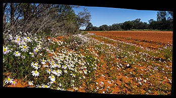
Large open plains, ends of grassy forests and rusty rocky cliffs dominate the landscape.[2]
- Images from the park
-
 Grey-crowned babbler in the park
 -
-
 Floodwaters near Yanda campground


See also[edit]
References[edit]
- ^ a b "Gundabooka National Park: Park management". Office of Environment & Heritage. Government of New South Wales. Retrieved 12 October 2014.
- ^ "Gundabooka National Park | Learn more". NSW National Parks. Retrieved 24 September 2021.
External links[edit]
- "Gundabooka National Park and Gundabooka State Conversation Area: Plan of management" (PDF). NSW National Parks & Wildlife Service (PDF). Government of New South Wales. 28 October 2005. ISBN 1-74122-053-X.
| International | |
|---|---|
| National | |
This New South Wales protected areas related article is a stub. You can help Wikipedia by expanding it. |