
Talk:Nauvoo, Alabama
| This article is rated Start-class on Wikipedia's content assessment scale. It is of interest to the following WikiProjects: |
||||||||
| ||||||||
Untitled[edit]
Wondering how to edit this U.S. City Entry?
The WikiProject U.S. Cities standards might help.
Research question[edit]
(copied from Wikipedia talk:WikiProject Latter Day Saint movement)
Does Nauvoo, Alabama have any historical ties to Nauvoo, Illinois? It seems like a rather unusual name for it not to. I see that both started out in respective Hancock Counties. I also see that Winston County, Alabama (formerly Hancock) refused to join the Confederacy, which made me wonder whether it contrasts demographically with the surrounding counties. -- Beland 03:40, 27 August 2005 (UTC)
- Well -- interesting little question. I didn't know, but this link says the town was renamed after Nauvoo, Illinois. [1] But it doesn't say why. Maybe more research is in order. WBardwin 04:36, 27 August 2005 (UTC)
Reconciling "History" section with sources cited.[edit]
Earlier this year, User:Guy954 made a revision adding the following statement to the end of the "History" section:
- Nauvoo is indicated on the map called the "Military map showing the marches of the United States forces under command of Maj. Genl. W. T. Sherman, U.S.A., during the years 1863, 1864, 1865." Printed in 1865.
This is an interesting issue. The source that User:Guy954 is citing can be viewed online, thanks to the Library of Congress:
Military map showing the marches of the United States forces under command of Maj. Genl. W. T. Sherman, U.S.A., during the years 1863, 1864, 1865. (St. Louis, Mo.: 1865).
Unfortunately, I do not think that a careful reading of the map can support the claim that the currently-existing town of Nauvoo, Alabama is indicated as existing in the mid-1860s.
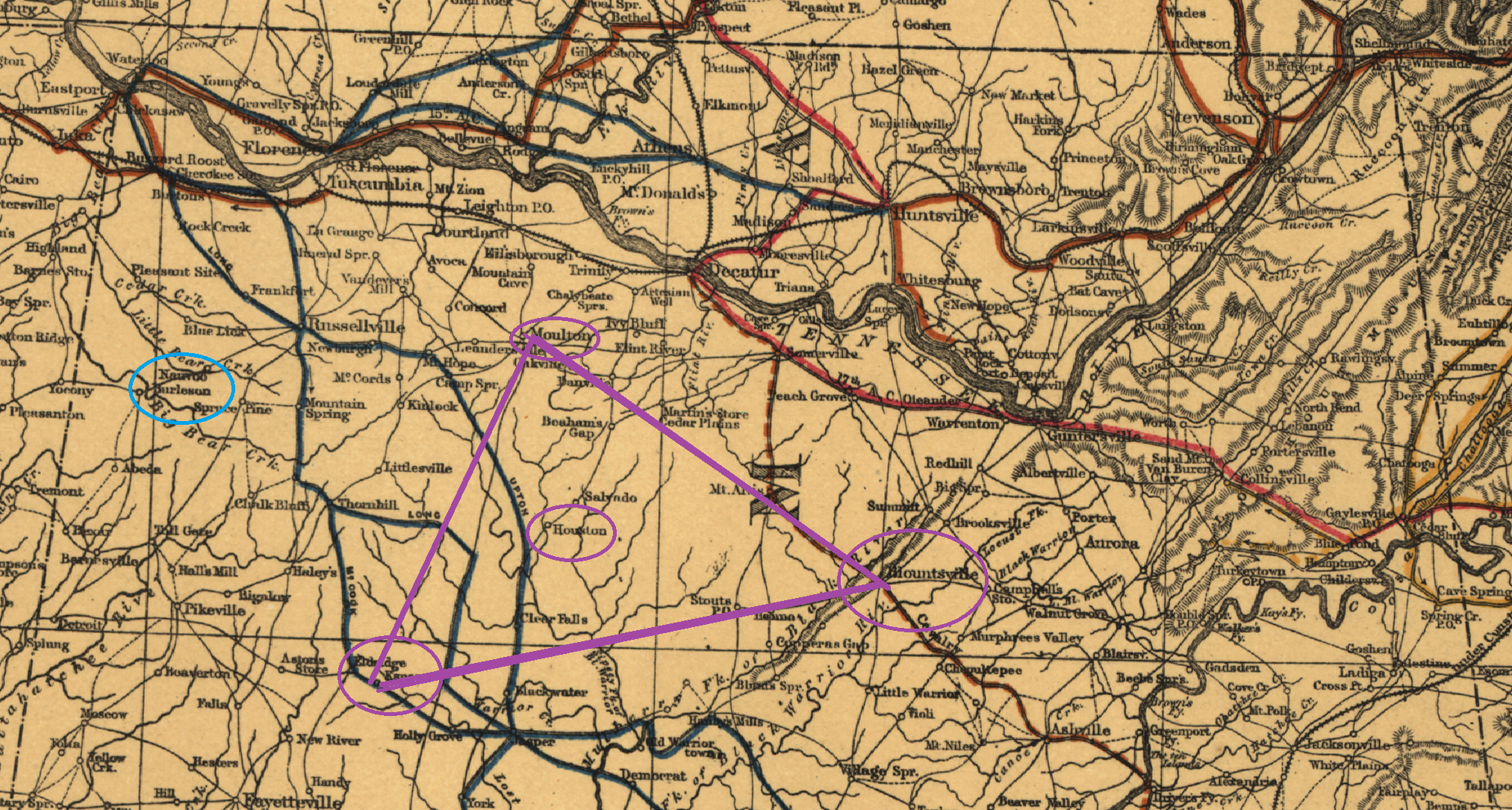
The reason it does not indicate this is that there is a settlement named "Nauvoo" indicated on the Sherman campaign map. But it is not located anywhere near where the town of Nauvoo is now located, or anywhere near where it was located when the railroad stop was established in the 1880s. Like contemporary Nauvoo, the old "Nauvoo" marked on the 1865 map is located in northwestern Alabama. But contemporary Nauvoo is located on the north-south boundary between Walker County and Winston County. It is located within a triangle between three cities that are all indicated on the 1865 map -- Kansas, Alabama to the southwest, Moulton, Alabama to the north, and Blountsville, Alabama to the southeast. (In particular, it's located in between Kansas and Houston, Alabama, also on the 1865 map. Within this triangle, there is no settlement marked where Nauvoo, Alabama is today, and no settlement marked as Nauvoo anywhere within the triangle.
The settlement marked as "Nauvoo" on the 1865 map is located well to the northwest, just by the town of Burleson (today Old Burleson, Alabama, located in Franklin County near the Mississippi border and near Russellville, Alabama. It is far to the west of Kansas, Alabama, let alone contemporary Nauvoo.
I marked out the relevant region of the 1865 map in this close-up image. The light blue ellipse marks where Nauvoo and Burleson are marked on the map; the dark purple triangle connecting Moulton, Kansas and Blountsville, with Houston marked out in the middle, show the region of the map within which the site of contemporary Nauvoo is located.
I think it's really interesting that only 25 years or so before the apparent founding of modern-day Nauvoo, there was another town, also in northwestern Alabama, which was also called "Nauvoo." It might be an interesting topic for local historians to look into, to see if there are any links between the people or families or settlements that explain why the name was used for both the 1860s settlement and then proposed for the new 1880s town, when the latter was established near Blackwell's Crossing and Ingle Mills. If so, I think any information about any links that there may have been between the two settlement sites would make a really valuable and interesting contribution to this article. But in the meantime, in the absence of this informaiton, I do not think that the source cited (the 1865 map) actually supports the claim that the 1865 map indicates the existence or the location of the current town of Nauvoo back in the 1860s. It seems to indicate a different settlement, by the same name, located in a different part of the state far away from the site of the current town.
In the absence of a better idea, I've included a link to the source cited (the 1865 map), and retained a note about the presence of a "Nauvoo" settlement on it, but I have confined this point to a footnote, since the settlement marked on the map does not appear to be the same town as the modern-day settlement:
- 3. [...] A settlement in northwestern Alabama, labeled "Nauvoo," is indicated on the "Military map showing the marches of the United States forces under command of Maj. Genl. W. T. Sherman, U.S.A., during the years 1863, 1864, 1865." (St. Louis, Mo.: 1865), but this settlement, located far to the northwest near Burleson in Franklin County, near the Mississippi state line, appears to be unrelated to the contemporary town of Nauvoo, Alabama, which is located in between Kansas, Alabama and Houston, Alabama.