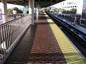
South Miami station
This article relies largely or entirely on a single source. (June 2021) |
| Metrorail metro station | |||||||||||||||
 Morning view of platform and southbound track | |||||||||||||||
| General information | |||||||||||||||
| Location | 5949 South Dixie Highway Miami, Florida | ||||||||||||||
| Coordinates | 25°42′18″N 80°17′20″W / 25.70500°N 80.28889°W | ||||||||||||||
| Owned by | Miami-Dade County | ||||||||||||||
| Platforms | 1 island platform | ||||||||||||||
| Tracks | 2 | ||||||||||||||
| Connections | |||||||||||||||
| Construction | |||||||||||||||
| Parking | Garage (1774 spaces) | ||||||||||||||
| Bicycle facilities | Rack | ||||||||||||||
| Accessible | Yes | ||||||||||||||
| Other information | |||||||||||||||
| Station code | SMI | ||||||||||||||
| History | |||||||||||||||
| Opened | May 20, 1984[1] | ||||||||||||||
| Passengers | |||||||||||||||
| 2012 | 1.1 million[2] | ||||||||||||||
| Services | |||||||||||||||
| |||||||||||||||
South Miami station is a station on the Metrorail rapid transit system in South Miami, Florida. This station is located at the intersection of South Dixie Highway (US 1) and Sunset Drive (SW 72nd Street/SR 986), two blocks west of Red Road (West 57th Avenue). It opened to service May 20, 1984.[1]
South Miami provides access to The Shops at Sunset Place, as well as a number of local hospitals.
Station layout[edit]
The station has two tracks served by an island platform, with a parking garage immediately west of the platform.
References[edit]
- ^ a b "Free Rides Bring Out Thousands to Opening of Miami Metrorail". The Tampa Tribune. May 21, 1984. pp. 1B–2B. Retrieved September 18, 2023 – via Newspapers.com.

- ^ "Ridership Technical Reports".
External links[edit]
 Media related to South Miami (Metrorail station) at Wikimedia Commons
- MDT – Metrorail Stations
- Station from Google Maps Street View

