Allington, Dorset
| Allington | |
|---|---|
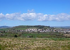
 Allington and Allington Hill from the south | |
Location within Dorset | |
| Population | 766 [1] |
| OS grid reference | SY459933 |
| • London | 123 mi (198 km) WSW |
| Civil parish |
|
| Shire county | |
| Region | |
| Country | England |
| Sovereign state | United Kingdom |
| Post town | Bridport |
| Postcode district | DT6 |
| Police | Dorset |
| Fire | Dorset and Wiltshire |
| Ambulance | South Western |
| Website | http://www.allington.co.uk/ |
Allington is a village and civil parish in Dorset, England, 1 mile (1.6 km) north-west from the town of Bridport, with which it is physically contiguous; much of Allington lies within Bridport parish. In the 2011 census Allington civil parish had 371 dwellings,[2] 339 households and a population of 766.[1]
Allington Hill rises to 89 metres (292 ft) above the village; it is managed by the Woodland Trust.[3] The hill is characteristic of the Upper Greensand hills and ridges found in the Marshwood and Powerstock Vales National Character Area.
In 1086 in the Domesday Book Allington was recorded as Adelingtone;[4] it had 21 households, 3 ploughlands, 10 acres (4.0 ha) of meadow and one mill. It was in Goderthorn Hundred and the lord and tenant-in-chief was Turstin son of Rolf.[5]

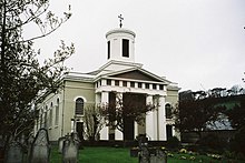
The parish church at North Allington, dedicated to St Swithun, was designed by Charles Wallis of Dorchester and built in 1826–27, and is a Grade II* listed building. It is in classical style, and is unusual for the survival of a high proportion of the original internal fittings, including the pews, gallery, a pulpit (of two originally present) and glazing.[6]
References[edit]
- ^ a b "Area: Allington (Parish). Key Figures for 2011 Census: Key Statistics". Neighbourhood Statistics. Office for National Statistics. Archived from the original on 21 October 2016. Retrieved 2 May 2013.
- ^ "Area: Allington (Parish). Dwellings, Household Spaces and Accommodation Type, 2011 (KS401EW)". Neighbourhood Statistics. Office for National Statistics. Archived from the original on 21 October 2016. Retrieved 10 February 2015.
- ^ "Allington Hill & Cooper's Wood". Woodland Trust. Archived from the original on 2 April 2015. Retrieved 29 March 2015.
- ^ "Dorset A-G". The Domesday Book Online. domesdaybook.co.uk. Retrieved 29 March 2015.
- ^ "Place: Allington". Open Domesday. domesdaymap.co.uk. Archived from the original on 2 April 2015. Retrieved 29 March 2015.
- ^ Historic England. "Church of St Swithun (1216300)". National Heritage List for England. Retrieved 2 May 2013.
External links[edit]
 Media related to Allington, Dorset at Wikimedia Commons

