Methven (Māori: Piwakawaka) is a small town in the Canterbury region of the South Island of New Zealand. It is located near the western edge of the Canterbury Plains, 35 km (22 mi) north of Ashburton and 95 km (59 mi) west of Christchurch, and at an elevation of 320 m (1,050 ft).[4] The town is a service centre for agriculture in the surrounding area, and is a base for skiing at the nearby Mount Hutt skifield. The town slogan is "Amazing Space".[5]
In 1869, Robert Patton purchased a 500 acres (200 ha) farm property and called it Methven, after the name of his old home town in Perthshire, Scotland. The name of the farm subsequently became the name of the town and surrounding district. Sections in the township were offered for sale by public auction on 24 June 1878 at South Rakaia, and sold for between 20 and 95 pounds.[6]
In 1879, Robert Patton applied to the Ashburton Licensing Court for a license to operate a new house at Methven to be called the Methven Hotel.[7] A hotel was built in 1880.[8] In 1882, Patton applied to the Licensing District of Mount Hutt for a publican's license for the 24 room Methven hotel.[9] The Methven Branch railway line from Rakaia to Methven was completed in 1880. The terminus of the railway line was at the junction of six roads, in the centre of the town as it stands today. By 1882–83, further sections of land were sold around the area that would subsequently become the town of Methven. By the time that Robert Patton died on 20 October 1889,[10] Methven had a butcher, baker, grocer, draper and a blacksmiths, in addition to the hotel.[11]
The Methven School was opened on 7 February 1882, with an opening school roll of 41. The Chairman of the School Committee was Robert Patton. The school remained as a Primary school, until secondary schooling was established in Methven in 1925.[12]
A notable early farmer in the Methven district was Duncan Cameron. He was initially the manager of a large 21,000 acres (8,500 ha) property called Springfield, employing 100 men through the year, and 200 during harvesting. Cameron became the owner of the Springfield property in 1890. He had 4,000 acres (1,600 ha) in crops most years, and in one year had 5,500 acres in wheat. He was an early pioneer of irrigation in the district. By 1876, he had constructed 13 miles (21 km) of water races at Springfield, and this grew to 40 miles (64 km) by 1880. His use of irrigation enabled cropping and increased stock-carrying, and led the way for later investments in irrigation in the district. Cameron was also a pioneer for the frozen meat export industry.[13]
The Mount Hutt Road Board office was completed in 1879. Despite the depression of the 1880s and 1890s, the Methven library was built in 1883.[14] The Anglican church was built in 1880 and the Catholic church in 1888. The population of Methven town was 300 people in 1902. Methven contributed troops to the First World War with 69 of them losing their lives. In the 1920s Methven slowly changed from having livery stables and smithies to garages and engineering firms to service cars and farm machinery. The 1920s also saw the arrival in Methven of companies such as Dalgety's and Wright Stevenson and Co. Trucking firms also aimed to compete with the railways to ship farm goods such as wool to the ports. Electricity also arrived around this time. The farm labourers who working on the local farms often resided in Methven or came to Methven to socialize after work. Farm labourers frequented the grocery stores, clothing retailer, pubs, billiard halls, brothels, and boarding houses that were present in Methven in the early days of the town. The Methven branch railway line closed in 1976.
For the first 100 years of Methven's existence, its primary role was that of servicing the needs of farmers and farm labour.[15]
Methven expanded dramatically in 2021 with over three hundred residential sections sold. This is expected to lead to an increase in the population to 2411 people by 2023. The population was expected to climb to this number in the year 2048 according to Ashburton District Council projections.[16]
Methven is described by Statistics New Zealand as a small urban area, and covers 4.77 km2 (1.84 sq mi)[2] and had an estimated population of 2,010 as of June 2023,[3] with a population density of 421 people per km2.
Before the 2023 census, Methven had a smaller boundary, covering 4.18 km2 (1.61 sq mi).[2] Using that boundary, Methven had a population of 1,779 at the 2018 New Zealand census, an increase of 60 people (3.5%) since the 2013 census, and an increase of 375 people (26.7%) since the 2006 census. There were 723 households, comprising 906 males and 873 females, giving a sex ratio of 1.04 males per female. Almost 50% of Methven residents are married and a further 33.7% have never married nor been in a civil union. The median age was 39.9 years (compared with 37.4 years nationally), with 351 people (19.7%) aged under 15 years, 318 (17.9%) aged 15 to 29, 843 (47.4%) aged 30 to 64, and 267 (15.0%) aged 65 or older.
Ethnicities were 91.6% European/Pākehā, 8.4% Māori, 1.2% Pasifika, 3.5% Asian, and 2.2% other ethnicities. People may identify with more than one ethnicity.
The percentage of people born overseas was 21.4, compared with 27.1% nationally.
Although some people chose not to answer the census's question about religious affiliation, 54.3% had no religion, 36.9% were Christian, 0.3% had Māori religious beliefs, 0.3% were Hindu, 0.2% were Buddhist and 1.5% had other religions.
Of those at least 15 years old, 294 (20.6%) people had a bachelor's or higher degree, and 240 (16.8%) people had no formal qualifications. The median income was $39,200, compared with $31,800 nationally. 282 people (19.7%) earned over $70,000 compared to 17.2% nationally. The employment status of those at least 15 was that 822 (57.6%) people were employed full-time, 240 (16.8%) were part-time, and 36 (2.5%) were unemployed.[19]
Cairnbrae statistical area surrounds but does not include Methven, and covers 541.21 km2 (208.96 sq mi)[2] It had an estimated population of 1,630 as of June 2023,[20] with a population density of 3.0 people per km2.
Before the 2023 census, Cairnbrae had a larger boundary, covering 542.76 km2 (209.56 sq mi).[2] Using that boundary, it had a population of 1,449 at the 2018 New Zealand census, an increase of 45 people (3.2%) since the 2013 census, and an increase of 213 people (17.2%) since the 2006 census. There were 546 households, comprising 780 males and 663 females, giving a sex ratio of 1.18 males per female. The median age was 35.2 years (compared with 37.4 years nationally), with 360 people (24.8%) aged under 15 years, 258 (17.8%) aged 15 to 29, 714 (49.3%) aged 30 to 64, and 117 (8.1%) aged 65 or older.
Ethnicities were 83.9% European/Pākehā, 5.2% Māori, 1.2% Pasifika, 13.7% Asian, and 1.2% other ethnicities. People may identify with more than one ethnicity.
The percentage of people born overseas was 25.1, compared with 27.1% nationally.
Although some people chose not to answer the census's question about religious affiliation, 42.7% had no religion, 50.7% were Christian, 0.4% were Hindu, 0.2% were Muslim, 0.2% were Buddhist and 0.8% had other religions.
Of those at least 15 years old, 204 (18.7%) people had a bachelor's or higher degree, and 147 (13.5%) people had no formal qualifications. The median income was $43,300, compared with $31,800 nationally. 222 people (20.4%) earned over $70,000 compared to 17.2% nationally. The employment status of those at least 15 was that 669 (61.4%) people were employed full-time, 219 (20.1%) were part-time, and 18 (1.7%) were unemployed.[21]
The warmest months of the year are January and February, with an average high temperature of 22 °C. The coldest month of the year occurs in July, when the average high temperature is 9 °C (48 °F). Monthly rainfall ranges between an average of 76 mm (3.0 in) in April to 103 mm (4.1 in) in July.[22] Snow falls a few days each year in Methven in the winter months of June, July and August.[22]
Statue commemorating the centennial of Methven and Districts (1879–1979)
Methven is a rural service town that supports the local region. Dairy farming, sharecropping, sheep farming and seed production and distribution are major players in the farming industry around Methven.[5][23][24]
The Mount Hutt Memorial Hall (160 Main Street, Methven) contains the New Zealand Alpine & Agriculture Encounter. It aims to provide an understanding of farming in the area.[25]
Methven has an annual A & P Show each year at the A & P Show grounds in Methven. The 2020 A & P show was cancelled due to the Covid-19 Lockdown in New Zealand.[26]
In 1971, the Methven Lions Club studied whether Mount Hutt could be developed into a ski field. The study suggested that this was possible and it led to the opening of a skifield in 1973. Mount Huttskifield is around half an hour away from Methven. Although the majority of skiers usually made the journey to Mount Hutt from Christchurch on a daily basis, some would stay the weekend in Methven and need accommodation, dinner and services. This led to the establishment of a number of hotels, motels, restaurants and other tourist activities being developed. The town centre was redeveloped with 14 new shops built in 1975. Development continued and by 1989 Methven had five hotels, three motels, twenty ski lodges, two camping grounds and nine restaurants.[15]
During winter, Methven undergoes a significant transformation. A number of cafes, bars, and restaurants lie relatively dormant over the summer months, but become busy during the ski season. Similarly, the town's accommodation providers have a strongly seasonal trade. The New Zealand Ski Heritage Museum was established in 2000. It is located in the Mount Hutt Memorial Hall (160 Main Street, Methven). It includes ski fashions, antique ski equipment and Winter Olympic memorabilia.[27] Methven is also a base for heliskiing in the Arrowsmith range of mountains.[28][29] The annual Peak to Pub race starts at the top of Mount Hutt where competitors ski two kilometres ski down the mountain to the car park. This is followed by an 18km mountain bike ride down the ski road, followed by a 12km run into Methven.[30]
Methven tourism businesses have struggled in 2020 due to the Covid-19 virus. The Methven Resort Hotel, was placed into liquidation in June 2020. The hotel had a 100-seat restaurant, a large swimming pool and multiple spa pools.[31]
In addition to skiing, horse riding is popular and there are a number of companies that offer horse treks in and around Methven. Hot air ballooning is also possible to do in Methven.[32] The Methven i-SITE Visitor Centre is located at 160 Main Street, Methven. The Methven skatepark was opened in 2020. It sits in the centre of town in the reserve at Bank and McMillan Streets. Significant local fundraising efforts were required to make the skatepark a reality.[33][34][35]
The start of the Rakaia Gorge Walkway is an 11-kilometre drive from Methven. The track is 10.4 kilometres there and back which will take the average walker three to four hours to complete the return journey.[37]
Short walks in the Mount Hutt Forest (which is 12.5 kilometres from Methven) include the Rhododendron Walk; Te Awa Awa Walk; Alder Track; Opuke Track and the Ridge Track. A longer walk is the Pudding Hill Stream (8.25 kilometres, 3 hours one way) and the Scotts Saddle Track (4.5 kilometres, 2 hours one way)[37]
The Mt Alford car park is a 12.5-kilometre drive from Methven. The Mt Alford Track itself is a 4.6-kilometre-long track that climbs to the summit of Mt Alford (1,171 m). It takes approximately three hours one way. The tracks are closed each year in September and October during lambing season.[37]
Bike Methven has developed a range of mountain bike trails around Methven which cover cross-country, enduro, and downhill trails. The Mount Hutt Bike Park is home to 30 kilometres of trails that are within five minutes of Methven.[40][41]
The Methven Rodeo is held annually in October each year and attendances can exceed 6000 people.[42] Events include Barrel Racing, Bull Riding, Saddle Bronc, Steer Wrestling and Team Roping.[43][44]
The New Zealand Government's provincial growth fund provided a $7.5 million government loan to help fund a new hot pools spa complex which was built next to the Methven Trotting Club. It has both family bathing and an adult-exclusive area. The water is heated by solar power.[45][46] The hot pools opened in November 2021 and were described "as money well spent amid challenging times".[47]
The War Memorial was unveiled in February 1930.[52] It commemorates the 69 men lost in the First World War and the 15 men lost in the Second World War.[53]
This was built in 1917 at 7 Bank Street. It was damaged in the Canterbury earthquakes and was a category 2 historic place. It was demolished in 2013.[54]
Built between 1883 and 1884 at 60 Main Street, in an Italianate style. It was damaged in the Canterbury earthquakes and was a category 2 historic place. It was demolished in 2013.[54]
The Road Board Building was built in 1879 on Methven's Main Street and is one of the earliest buildings in the town. The building was classified as a Category 2 historic place and registered on the New Zealand Heritage List in October 2019.[55] The building currently serves as the Methven Toy Library.[56]
The Methven Post Office reopened as an Irish bar and restaurant in 2015. The original bank safe and other historical items still remain in the building.[57]
The Rangitata Diversion Race or RDR is a combined irrigation and power generation scheme that diverts water from the Rangitata River to irrigate over 100,000hectares of farmland in mid-Canterbury. The main canal is 67km long, and passes to the west and north of Methven township. The RDR project was the first major river diversion in New Zealand, and the largest irrigation scheme in the country. Construction began in 1937, paused for World War 2 and was completed in 1945.[58][59]
The cast and crew of the movie Z for Zachariah stayed in Methven in February and March 2014 while shooting scenes at Washpen Falls near Windwhistle. After a party at the Blue Pub in Methven, Hollywood actor Chris Pine was caught drink-driving by police.[61][62]
During the 2020 Covid-19 lockdown in New Zealand, Lynda from the Topp Twins and her wife Donna played music from the back of their truck on the way to the supermarket to bring some fun into peoples lives in Methven.[63]
The Mountain Thunder motorcycle street race was an annual event held in Methven on Easter Saturday for eight years until 2017. Motorcyclists raced on a tight one-kilometre road circuit around the town centre. Speeds of up to 200 kilometres per hour were reached. Competitors came from across New Zealand to compete at this event. The 2017 event was marred by a fatality in one of the races, and the organisers announced later that year that the 2017 event would be the last.[64][65]
Methven Primary School is a state contributing primary (years 1 to 6) school. It has 232 students as of February 2024.[66] There are 25 staff members who work at the school.[67]
Mount Hutt College is a state Year 7 to 13 secondary school. It has 561 students as of February 2024.[66]
Our Lady of Snow School is a state-integrated Catholic full primary (years 1 to 8) school. It has 34 students as of February 2024.[66]
Methven was home to Rajah, New Zealand's first police dog.[70] A bronze statue of Rajah sits outside the Mt Hutt Function Centre. It was unveiled on 8 February 2015.[53]
^"Ashburton Licensing Court". Ashburton Herald. 9 December 1879. Archived from the original on 7 October 2021. Retrieved 23 September 2021 – via Papers Past.
^ abcdCampbell, Hugh R; Fairweather, John R (January 1991). Methven and Mt Somers: Report on socio-economic history and current social structure. Lincoln University. hdl:10182/229.
^"Mt Hutt Bike Park". www.bigals.co.nz. Archived from the original on 19 January 2020. Retrieved 10 October 2020.
^"Methven Rodeo Club". Methven Rodeo Club | Methven | Mid Canterbury | New Zealand. Archived from the original on 24 October 2020. Retrieved 10 October 2020.
McCausland, Ray; Holmes, Robert G.; Goldsbrough, Guy H.; Currie, Walter J. (1979). Thompson, Mervyn (ed.). Unto the hills: Methven & Districts Centennial 1879–1979. Methven and Districts Centennial Committee.

.jpg)


 The Pipe Shed (October 2020)
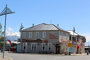 Brown Pub, Methven, Mt Hutt in the background (October 2020)
 Blue Pub, Methven, (October 2020)
 Methven War Memorial
 Mount Hutt Road Board Building (October 2020)
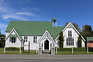 All Saints Church, Methven (October 2020)
.jpg)


