
Thompsons, Texas
Thompsons, Texas | |
|---|---|
 US post office at Thompsons, Texas | |
 Location of Thompsons, Texas | |
| Coordinates: 29°29′11″N 95°36′21″W / 29.48639°N 95.60583°W | |
| Country | United States |
| State | Texas |
| County | Fort Bend |
| Area | |
| • Total | 8.32 sq mi (21.55 km2) |
| • Land | 4.93 sq mi (12.78 km2) |
| • Water | 3.39 sq mi (8.77 km2) |
| Elevation | 66 ft (20 m) |
| Population (2010) | |
| • Total | 246 |
| • Estimate (2019)[2] | 350 |
| • Density | 70.95/sq mi (27.39/km2) |
| Time zone | UTC-6 (Central (CST)) |
| • Summer (DST) | UTC-5 (CDT) |
| ZIP code | 77481 |
| Area code | 281 |
| FIPS code | 48-72740[3] |
| GNIS feature ID | 1348510[4] |
Thompsons is a town in Fort Bend County, Texas, United States, within the Houston–Sugar Land–Baytown metropolitan area. The population was 246 at the 2010 census.[5]
Geography[edit]

Thompsons is located south of the Brazos River in east-central Fort Bend County at 29°29′11″N 95°36′21″W / 29.48639°N 95.60583°W (29.486494, –95.605803).[6] Richmond, the county seat, is 12 miles (19 km) to the northwest. According to the United States Census Bureau, Thompsons has a total area of 8.3 square miles (21.5 km2), of which 4.9 square miles (12.8 km2) is land and 3.4 square miles (8.8 km2), or 40.71%, is water.[5]
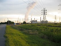
Smithers Lake, an artificial impoundment, along with its associated W.A. Parish Power Plant occupies most of the western half of the town itself. The ETJ of Sugar Land borders the northern end of Thompsons' ETJ; that of Rosenberg is on the west; Missouri City's approaches from the east.[7]
Climate[edit]
The climate in this area is characterized by hot, humid summers and generally mild to cool winters. According to the Köppen Climate Classification system, Thompsons has a humid subtropical climate, abbreviated "Cfa" on climate maps.[8]
Demographics[edit]
| Census | Pop. | Note | %± |
|---|---|---|---|
| 1980 | 240 | — | |
| 1990 | 167 | −30.4% | |
| 2000 | 236 | 41.3% | |
| 2010 | 246 | 4.2% | |
| 2020 | 156 | −36.6% | |
| U.S. Decennial Census[9] | |||
As of the census[3] of 2000, there were 236 people, 93 households, and 73 families residing in the town. The population density was 38.1 inhabitants per square mile (14.7/km2). There were 114 housing units at an average density of 18.4 per square mile (7.1/km2). The racial makeup of the town was 43.64% White, 47.03% African American, 0.85% Native American, 2.12% Asian, 3.81% from other races, and 2.54% from two or more races. Hispanic or Latino of any race were 8.05% of the population.
There were 93 households, out of which 29.0% had children under the age of 18 living with them, 53.8% were married couples living together, 20.4% had a female householder with no husband present, and 21.5% were non-families. 19.4% of all households were made up of individuals, and 6.5% had someone living alone who was 65 years of age or older. The average household size was 2.54 and the average family size was 2.82.
In the town, the population was spread out, with 22.5% under the age of 18, 11.0% from 18 to 24, 26.3% from 25 to 44, 28.8% from 45 to 64, and 11.4% who were 65 years of age or older. The median age was 39 years. For every 100 females, there were 90.3 males. For every 100 females age 18 and over, there were 84.8 males.
The median income for a household in the town was $32,083, and the median income for a family was $32,321. Males had a median income of $38,125 versus $22,222 for females. The per capita income for the town was $29,977. About 20.0% of families and 20.4% of the population were below the poverty line, including 21.4% of those under the age of eighteen and 29.7% of those 65 or over.
Government and infrastructure[edit]
The United States Postal Service operates the Thompsons Post Office at 222 Oilfield Road.[10] The city was first incorporated in 1979 and has a mayor council form of government. The first mayor was mayor G. W. Longserre who was succeeded by current mayor Freddie Newsome.
Government and infrastructure[edit]
Fort Bend County does not have a hospital district. OakBend Medical Center serves as the county's charity hospital which the county contracts with.[11]
Education[edit]
Thompsons is zoned to Lamar Consolidated Independent School District schools.[12] It is zoned to George Ranch High School.[13]
Gallery[edit]
-
 Thompsons road sign on FM 2759
 -
 Grand old house in Thompsons
 -
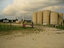 Lease in Thompsons Oil Field
 -
-
 Mt Pilgrim Missionary Baptist Church
 -
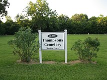 Thompsons Cemetery on FM 2759


References[edit]
- ^ "2019 U.S. Gazetteer Files". United States Census Bureau. Retrieved August 7, 2020.
- ^ a b "Population and Housing Unit Estimates". United States Census Bureau. May 24, 2020. Retrieved May 27, 2020.
- ^ a b "U.S. Census website". United States Census Bureau. Retrieved January 31, 2008.
- ^ "US Board on Geographic Names". United States Geological Survey. October 25, 2007. Retrieved January 31, 2008.
- ^ a b "Geographic Identifiers: 2010 Demographic Profile Data (G001): Thompsons town, Texas". U.S. Census Bureau, American Factfinder. Retrieved August 31, 2016.[dead link]
- ^ "US Gazetteer files: 2010, 2000, and 1990". United States Census Bureau. February 12, 2011. Retrieved April 23, 2011.
- ^ Fort Bend County Cities & ETJs (Map). February 2019. Retrieved January 2, 2022.
- ^ Climate Summary for Thompsons, Texas
- ^ "Census of Population and Housing". Census.gov. Retrieved June 4, 2015.
- ^ "Post Office Location - THOMPSONS." United States Postal Service. Retrieved on December 4, 2008.
- ^ Knipp, Bethany (November 2, 2016). "Fort Bend County lacks hospital district". Community Impact Newspaper. Retrieved October 18, 2021.
- ^ "2020 CENSUS - SCHOOL DISTRICT REFERENCE MAP: Fort Bend County, TX" (PDF). U.S. Census Bureau. Retrieved September 21, 2022. - Text list - Compare with LCISD boundary maps.
- ^ "High School Attendance Zones" (PDF). Lamar Consolidated Independent School District. Retrieved September 21, 2022. - Compare with the Census map.
External links[edit]
- Thompsons, Texas from the Handbook of Texas Online
| Counties |  | |
|---|---|---|
| "Principal" cities | ||
| Other cities |
For a complete listing, see list of cities and towns in Houston–The Woodlands–Sugar Land MSA | |
| Unincorporated areas | ||
| Bodies of water | ||
Municipalities and communities of Fort Bend County, Texas, United States | ||
|---|---|---|
| Cities |  | |
| Town | ||
| Villages | ||
| CDPs | ||
| Other communities | ||
| Former communities | ||
| Ghost towns | ||
| Footnotes | ‡This populated place also has portions in an adjacent county or counties ±Former CDP annexed by Missouri City ^Former CDP annexed by Sugar Land #Still active as a community, but is no longer listed as a census-designated place | |