User:Ato/Maps

From Wikipedia, the free encyclopedia

I plan to make (vector) maps of Turkey and its provinces with subprovinces. Here are useful links, hopefully it will include some results soon as well.

Rules[edit]

Tools[edit]

  • Inkscape: an vector graphics editor.
  • potrace: a command line bitmap to vector converter; it is also built into Inkscape.

Examples[edit]

Locator Maps[edit]

By Morwen. Uses medium blue seas, thin black lines for both coasts and borders, and the light red for the highlighted area.

Subdivisions[edit]

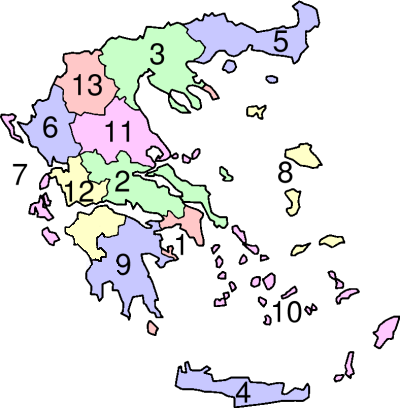
Peripheries of Greece[edit]

  1. Attica
  2. Central Greece
  3. Central Macedonia
  4. Crete
  5. East Macedonia and Thrace
  6. Epirus
  7. Ionian Islands
  8. North Aegean
  9. Peloponnesos
  10. South Aegean
  11. Thessaly
  12. West Greece
  13. West Macedonia

Map showing Peripheries of Greece

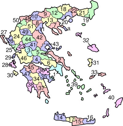
Prefectures of Greece[edit]

  1. Attica
  2. Euboea
  3. Evritania
  4. Fokis
  5. Fthiotis
  6. Viotia
  7. Khalkidhiki
  8. Imathia
  9. Kilkis
  10. Pella
  11. Pieria
  12. Serres
  13. Thessaloniki
  14. Chania
  15. Heraklion
  16. Lasithi
  17. Rethimno
  18. Drama
  19. Evros
  20. Kavala
  21. Rodhopi
  22. Xanthi
  23. Arta
  24. Ioannina
  25. Preveza
  1. Thesprotia
  2. Corfu
  3. Kefallinia
  4. Levkas
  5. Zakinthos
  6. Chios
  7. Lesbos
  8. Samos
  9. Arcadia
  10. Argolis
  11. Corinth
  12. Laconia
  13. Messinia
  14. Cyclades
  15. Dodecanese
  16. Kardhitsa
  17. Larissa
  18. Magnesia
  19. Trikala
  20. Achaea
  21. Aitolia-Acarnania
  22. Ilia
  23. Florina
  24. Grevena
  25. Kastoria
  26. Kozani