
Kerlingarfjöll
This article needs additional citations for verification. (June 2009) |
| Kerlingarfjöll | |
|---|---|
 The peaks of the Kerlingarfjöll area, close. | |
| Highest point | |
| Elevation | 1,477 m (4,846 ft) |
| Coordinates | 64°39′N 19°15′W / 64.650°N 19.250°W |
| Geography | |
 Kerlingarfjöll Location of Kerlingafjöll within Iceland | |
| Location | Iceland |
Kerlingarfjöll (Icelandic pronunciation: [ˈcʰɛ(r)tliŋkarˌfjœtl̥] ⓘ) is a 1,477 m (4,846 ft) tall mountain range in Iceland situated in the Highlands of Iceland near the Kjölur highland road. They are part of a large tuya volcano system of 100 km2 (39 sq mi). The volcanic origin of these mountains is evidenced by the numerous hot springs and rivulets in the area, as well as red volcanic rhyolite stone of which the mountains are composed. Minerals that have emerged from the hot springs also color the ground yellow, red and green.
The area was known formerly for its summer ski resort, but this was dismantled in 2000. Since 2000, Kerlingarfjöll has been operated as a highland resort, offering accommodation and food services to guests in the area.[1]
On March 17 in 2017 the Iceland Monitor stated that the Kerlingarfjöll Mountains and geothermal area were being turned into a nature reserve. Although parts of the place already had protection, the whole 367 square kilometres are to be under the protection of the state of Iceland. There have been thoughts of using the 140 degree Celsius hot springs as a geothermal power plant. The area is popular with hiking and the tourists.[2]
There are various half-day and one-day hiking trails in the area.[3]
-
 Kerlingarfjöll as seen from the Kjölur road.
 -
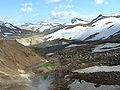 Valley in the Kerlingarfjöll area with geothermal activity.


See also[edit]
- Geography of Iceland
- Iceland plume
- Loðmundur, a mountain in Kerlingafjöll
- Volcanism of Iceland
References[edit]
- ^ "Kerlingarfjöll". Retrieved 2015-06-12.
- ^ "Kerlingarfjöll in the Icelandic highlands to become a reserve". Iceland Monitor.
- ^ "Hiking and Exploring in Kerlingarfjöll in the Highlands of Iceland". Travelade.
External links[edit]
- Hiking routes in Kerlingarfjoll
- Description and links to hiking tours Archived 2004-06-24 at the Wayback Machine
| International | |
|---|---|
| Geographic | |