
Macksburg, Iowa
Macksburg, Iowa | |
|---|---|
 Fire Bell in the city park | |
 Location of Macksburg, Iowa | |
| Coordinates: 41°12′51″N 94°11′8″W / 41.21417°N 94.18556°W | |
| Country | |
| State | |
| County | Madison |
| Area | |
| • Total | 1.98 sq mi (5.14 km2) |
| • Land | 1.98 sq mi (5.14 km2) |
| • Water | 0.00 sq mi (0.00 km2) |
| Elevation | 1,247 ft (380 m) |
| Population (2020) | |
| • Total | 97 |
| • Density | 48.92/sq mi (18.88/km2) |
| Time zone | UTC-6 (Central (CST)) |
| • Summer (DST) | UTC-5 (CDT) |
| ZIP code | 50155 |
| Area code | 641 |
| FIPS code | 19-48180 |
| GNIS feature ID | 0458713 |
Macksburg is a city in Madison County, Iowa, United States. The population was 97 at the time of the 2020 census.[2] It is part of the Des Moines–West Des Moines Metropolitan Statistical Area.
Geography[edit]
Macksburg is located at 41°12′51″N 94°11′8″W / 41.21417°N 94.18556°W (41.214250, -94.185618).[3]
According to the United States Census Bureau, the city has a total area of 1.99 square miles (5.15 km2), all of it land.[4]
History[edit]
Macksburg was laid out and platted in 1873. It was named for Dr. Joseph Hughes Mack, one of the original owners of the town site.[5]
Demographics[edit]
| Year | Pop. | ±% |
|---|---|---|
| 1880 | 204 | — |
| 1890 | 186 | −8.8% |
| 1900 | 235 | +26.3% |
| 1910 | 197 | −16.2% |
| 1920 | 228 | +15.7% |
| 1930 | 218 | −4.4% |
| 1940 | 255 | +17.0% |
| 1950 | 220 | −13.7% |
| 1960 | 174 | −20.9% |
| 1970 | 142 | −18.4% |
| 1980 | 132 | −7.0% |
| 1990 | 110 | −16.7% |
| 2000 | 142 | +29.1% |
| 2010 | 113 | −20.4% |
| 2020 | 97 | −14.2% |
| Source:"U.S. Census website". United States Census Bureau. Retrieved March 28, 2020. and Iowa Data Center Source: | ||
2010 census[edit]
At the 2010 census there were 113 people in 53 households, including 33 families, in the city. The population density was 56.8 inhabitants per square mile (21.9/km2). There were 59 housing units at an average density of 29.6 per square mile (11.4/km2). The racial makup of the city was 96.5% White, 1.8% Native American, and 1.8% from two or more races.[7]
Of the 53 households 28.3% had children under the age of 18 living with them, 47.2% were married couples living together, 9.4% had a female householder with no husband present, 5.7% had a male householder with no wife present, and 37.7% were non-families. 34.0% of households were one person and 11.3% were one person aged 65 or older. The average household size was 2.13 and the average family size was 2.76.
The median age was 44.4 years. 20.4% of residents were under the age of 18; 6.1% were between the ages of 18 and 24; 25.7% were from 25 to 44; 27.4% were from 45 to 64; and 20.4% were 65 or older. The gender makeup of the city was 52.2% male and 47.8% female.
2000 census[edit]
At the 2000 census there were 142 people in 62 households, including 40 families, in the city. The population density was 72.0 inhabitants per square mile (27.8/km2). There were 66 housing units at an average density of 33.4 per square mile (12.9/km2). The racial makup of the city was 97.18% White, 1.41% Asian, and 1.41% from two or more races.[8]
Of the 62 households 29.0% had children under the age of 18 living with them, 58.1% were married couples living together, 4.8% had a female householder with no husband present, and 33.9% were non-families. 32.3% of households were one person and 14.5% were one person aged 65 or older. The average household size was 2.29 and the average family size was 2.76.
The age distribution was 26.8% under the age of 18, 6.3% from 18 to 24, 20.4% from 25 to 44, 28.2% from 45 to 64, and 18.3% 65 or older. The median age was 38 years. For every 100 females, there were 89.3 males. For every 100 females age 18 and over, there were 96.2 males.
The median household income was $31,500 and the median family income was $36,964. Males had a median income of $29,688 versus $20,357 for females. The per capita income for the city was $14,080. There were none of the families and 5.6% of the population living below the poverty line, including no under eighteens and 6.5% of those over 64.
Education[edit]
Orient-Macksburg Community School District operates area public schools.[9]
Notable people[edit]
- Glenn L. Martin, American aviator and founder of the Glenn L. Martin Company, which is now part of the Lockheed Martin Corporation.
References[edit]
- ^ "2020 U.S. Gazetteer Files". United States Census Bureau. Retrieved March 16, 2022.
- ^ a b "2020 Census State Redistricting Data". census.gov. United states Census Bureau. Retrieved August 12, 2021.
- ^ "US Gazetteer files: 2010, 2000, and 1990". United States Census Bureau. February 12, 2011. Retrieved April 23, 2011.
- ^ "US Gazetteer files 2010". United States Census Bureau. Archived from the original on January 25, 2012. Retrieved May 11, 2012.
- ^ Mueller, Herman A. (1915). History of Madison County, Iowa, and Its People, Volume 1. S. J. Clarke Publishing Company. pp. 351.
- ^ "Census of Population and Housing". Census.gov. Retrieved June 4, 2015.
- ^ "U.S. Census website". United States Census Bureau. Retrieved May 11, 2012.
- ^ "U.S. Census website". United States Census Bureau. Retrieved January 31, 2008.
- ^ "Orient-Macksburg" (PDF). Iowa Department of Education. Retrieved April 1, 2020.
Gallery[edit]
-
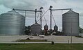 Farmer's Coop Grain elevators
 -
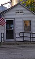 Post Office
 -
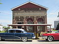 Old City Hall
 -
 Welcome sign in city park
 -
 Highway signs


Municipalities and communities of Madison County, Iowa, United States | ||
|---|---|---|
| Cities |  | |
| Townships | ||
| Unincorporated communities | ||
| Footnotes | ‡This populated place also has portions in an adjacent county or counties | |