
Lake Volta
| Lake Volta | |
|---|---|
 view of Lake Volta and Adomi bridge | |
 Lake Volta | |
 Lake Volta in Ghana | |
| Location | Ghana, West Africa |
| Coordinates | 6°30′N 0°0′E / 6.500°N 0.000°E |
| Lake type | Reservoir |
| Primary inflows | White Volta River Black Volta River |
| Primary outflows | Volta River |
| Catchment area | 385,180 km2 (148,720 sq mi) |
| Basin countries | Ghana |
| Surface area | 8,502 km2 (3,283 sq mi) |
| Average depth | 18.8 m (61 ft 8 in) |
| Max. depth | 75 m (246 ft) |
| Water volume | 148 km3 (32.6 × 10¹² gallons) |
| Shore length1 | 4,800 kilometres (2,980 mi) |
| Surface elevation | 85 m (279 ft) |
| 1 Shore length is not a well-defined measure. | |
Lake Volta, the largest artificial reservoir in the world based on surface area, is contained behind the Akosombo Dam which generates a substantial amount of Ghana's electricity. It is completely within the country of Ghana and has a surface area of 8,502 square kilometres (3,282+1⁄2 sq mi).[1] It extends from Akosombo in the south to the northern part of the country.[2][3]
Geography[edit]
Lake Volta lies along the prime meridian, six degrees north of the Equator. The lake's northernmost point is close to the town of Yapei, and its southernmost extreme is at the Akosombo Dam, 520 km (320 mi) downstream from Yapei. Akosombo Dam holds back both the White Volta River and the Black Volta River, which formerly converged where the middle of the reservoir now lies, to form the single Volta River. The present Volta River flows from the outlets of the dam's powerhouse and spillways to the Atlantic Ocean in southern Ghana.
The main islands within the lake are Dodi, Dwarf, and Kporve.[4] Digya National Park lies on part of the lake's western shore.
History[edit]
The lake was formed by the Akosombo Dam, which was originally conceived by the geologist Albert Ernest Kitson during the British colonial period in 1915, to exploit the river's energy for smelting locally-sourced bauxite. The idea regained prominence at the end of the colonial era after the World War II when Kwame Nkrumah became president of the Gold Coast colony and began striving for modernization of the land. British and local governments formed a joint preparatory commission, which concluded that over 60.000 people will have to be relocated, but that the lake will boost opportunities for fishing, thus helping to feed the population in the region. On the other hand, issues with water-related illnesses were predicted, such as malaria, trypanosomiasis, schistosomiasis, and onchocerciasis.[5]

Aluminium Limited, the main industrial sponsor of the project, withdrew after Ghana became independent in 1957. Revised plans dropped the idea of integrated aluminium industry and proposed smelting imported bauxite instead. Kaiser Aluminum entered the project at this point and after protracted negotiations, funding for the project was secured, but now without regard to residents of the impacted area as a cost-cutting measure. Construction thus began before the government started planning the resettlement. Soon after, a public agency was established, and organized construction of 52 replacement towns, which were envisioned to serve as a model for modernization and improving the livelihood of the local population. But because of the rush, the resettlement in 1964 turned out to be chaotic and inefficient. Poor organization caused the issues to continue long after the project's completion and caused significant hardship to the local population.[5] Together, 15,000 homes in 740 villages were flooded, necessitating resettlement of 78,000 people.[1]
In the long run, formation of the lake disrupted traditional fishing and farming practices in the region and caused a large spike in disease prevalence. Government-led modernization did not succeed, and people had to adapt to the new circumstances themselves.[5] Despite that, regional food production intensified in the decades after the construction of Akosombo dam, and the lake also opened a large navigable pathway to the north of the country and provided new opportunities for development of tourism which is gaining in prominence. On the other hand, water level has been decreasing recently because of global warming, reducing power generation.[6]
Economy[edit]
The Akosombo Dam produces 912 MW of electricity for the country, as well as for export to Togo, Benin, and other nearby countries to earn foreign exchange.[1] Lake Volta is also important for transportation, providing a waterway for both ferries and cargo watercraft. Since the huge lake lies in a tropical area, the water remains warm year-round naturally. Given good management, Lake Volta is the location of a vast population of fish and large fisheries.
The lake also attracts tourism, and tourist cruises visit the island of Dodi.[4]
Recent developments include a large-scale enterprise to harvest submerged timber from the flooded forests under Lake Volta. This project harvests high-value tropical hardwood without requiring additional logging or destruction of existing forest and, according to Wayne Dunn, "could generate the largest source of environmentally sustainable natural tropical hardwood in the world."[7] In addition to generating foreign currency for the region and reducing the dependence of locals on fishing as a primary economic activity, the removal of submerged trees is improving navigation on the lake and increasing safety.[7]
An estimated 7,000 to 10,000 children work in the fishing industry on Lake Volta. The nature of their employment has been described as slavery in The Guardian[8] and by the CNN Freedom Project. This has been described as sensationalism by Betty Mensah and the academic Samuel Okyere since many of the children and youth whose wages are given upfront to their parents grow up to become self-sufficient fishermen in adulthood who in turn hire children themselves and could therefore also be characterized as apprentices. They conclude that many children may suffer under exploitative work but are not enslaved.[9][10]

Photos[edit]
-
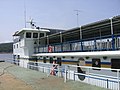
 A ferry on Lake Volta
 -
 Photograph of Lake Volta
 -
 Akosombo Port's signage
 -
 Trees in Lake Volta
 -
-


_Dock_%E2%88%92_Lake_Volta.jpg)

See also[edit]
- Lake Kariba, the world's largest reservoir by volume.
References[edit]
- ^ a b c "Lake Volta | lake, Ghana". Encyclopedia Britannica. Retrieved 2021-02-06.
- ^ "Lake Volta, Ghana". Visible Earth. NASA. 7 April 2002. Retrieved 7 March 2018.
- ^ "Largest, Tallest, Biggest, Shortest". McqsPoint. Archived from the original on 9 February 2019. Retrieved 9 February 2018.
- ^ a b "Dodi Island cruises". secureserver.net. Archived from the original on 2010-10-31.
- ^ a b c Miescher, Stephan F. (2021-10-01). "Ghana's Akosombo Dam, Volta Lake Fisheries & Climate Change". Daedalus. 150 (4): 124–142. doi:10.1162/daed_a_01876.
- ^ Gyau-Boakye, P. (2001). "Environmental impacts of the Akosombo Dam and effects of climate change on the lake levels". Environment, Development and Sustainability. 3 (1): 17–29. doi:10.1023/A:1011402116047.
- ^ a b "Harvesting an Underwater Forest". Archived from the original on March 4, 2012. Retrieved 28 May 2011.
{{cite web}}: CS1 maint: unfit URL (link) - ^ "Sons for Sale". www.theguardian.com. 22 March 2007.
- ^ Okyere, Samuel (18 March 2019). "How CNN reported on 'child slaves' who were not really enslaved". AlJazeera. Retrieved 30 July 2019.
- ^ "Ghanaian children wrongly taken in raids backed by US charity IJM". BBC News. July 10, 2023.
External links[edit]
- Lake Volta & Akosombo on Ghanaweb.com
- Volta Lake, International Lake Environment Committee Web site
- Gold exploration in the Volta region — Objective Capital Africa Resources Investment Conference (video)
- Lake Volta — more information on Ghana-Net.com